You are here: Home > Network List > O2 - Oklahoma Consolidated Temporary Seismic Networks Stations List
> Station SC04 Fox, Oklahoma, USA > Earthquake Result Viewer
SC04 Fox, Oklahoma, USA - Earthquake Result Viewer
| Earthquake location: |
Alaska Peninsula |
| Earthquake latitude/longitude: |
55.2/-157.7 |
| Earthquake time(UTC): |
2021/08/14 (226) 11:57:42 GMT |
| Earthquake Depth: |
4.8 km |
| Earthquake Magnitude: |
6.4 ml |
| Earthquake Catalog/Contributor: |
NEIC PDE/ak |
|
| Network: |
O2 Oklahoma Consolidated Temporary Seismic Networks |
| Station: |
SC04 Fox, Oklahoma, USA |
| Lat/Lon: |
34.36 N/97.47 W |
| Elevation: |
300 m |
|
| Distance: |
45.9 deg |
| Az: |
91.183 deg |
| Baz: |
316.191 deg |
| Ray Param: |
0.07099911 |
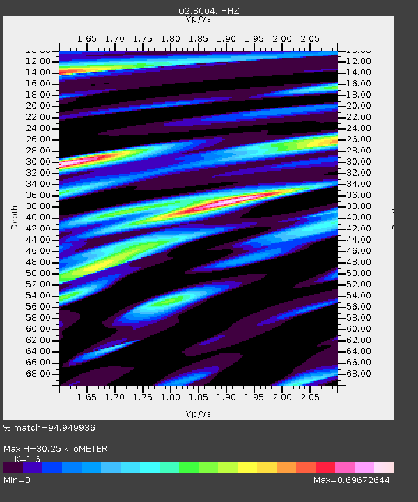
| Estimated Moho Depth: |
30.25 km |
| Estimated Crust Vp/Vs: |
1.60 |
| Assumed Crust Vp: |
6.426 km/s |
| Estimated Crust Vs: |
4.016 km/s |
| Estimated Crust Poisson's Ratio: |
0.18 |
|
| Radial Match: |
94.949936 % |
| Radial Bump: |
400 |
| Transverse Match: |
80.93207 % |
| Transverse Bump: |
400 |
| SOD ConfigId: |
25131211 |
| Insert Time: |
2021-08-28 12:16:48.626 +0000 |
| GWidth: |
2.5 |
| Max Bumps: |
400 |
| Tol: |
0.001 |
|

Signal To Noise
| Channel | StoN | STA | LTA |
| O2:SC04: :HHZ:20210814T12:05:35.265012Z | 11.357339 | 3.1490463E-6 | 2.7726972E-7 |
| O2:SC04: :HHN:20210814T12:05:35.265012Z | 4.9741244 | 1.151669E-6 | 2.3153201E-7 |
| O2:SC04: :HHE:20210814T12:05:35.265012Z | 6.264507 | 1.4111324E-6 | 2.2525833E-7 |
| Arrivals |
| Ps | 3.0 SECOND |
| PpPs | 11 SECOND |
| PsPs/PpSs | 14 SECOND |


