You are here: Home > Network List > O2 - Oklahoma Consolidated Temporary Seismic Networks Stations List
> Station SC09 Elmore City, Oklahoma, USA > Earthquake Result Viewer
SC09 Elmore City, Oklahoma, USA - Earthquake Result Viewer
| Earthquake location: |
Alaska Peninsula |
| Earthquake latitude/longitude: |
55.2/-157.7 |
| Earthquake time(UTC): |
2021/08/14 (226) 11:57:42 GMT |
| Earthquake Depth: |
4.8 km |
| Earthquake Magnitude: |
6.4 ml |
| Earthquake Catalog/Contributor: |
NEIC PDE/ak |
|
| Network: |
O2 Oklahoma Consolidated Temporary Seismic Networks |
| Station: |
SC09 Elmore City, Oklahoma, USA |
| Lat/Lon: |
34.55 N/97.37 W |
| Elevation: |
296 m |
|
| Distance: |
45.8 deg |
| Az: |
90.919 deg |
| Baz: |
316.068 deg |
| Ray Param: |
0.07103538 |
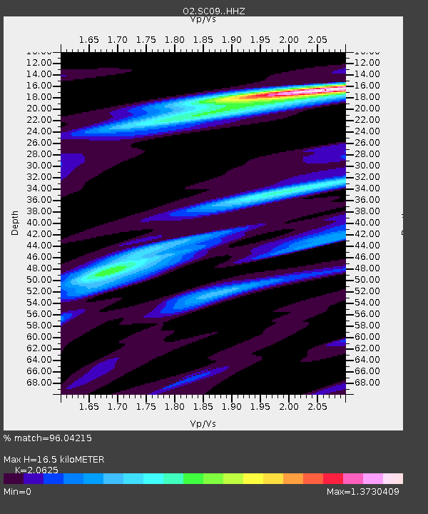
| Estimated Moho Depth: |
16.5 km |
| Estimated Crust Vp/Vs: |
2.06 |
| Assumed Crust Vp: |
6.426 km/s |
| Estimated Crust Vs: |
3.116 km/s |
| Estimated Crust Poisson's Ratio: |
0.35 |
|
| Radial Match: |
96.04215 % |
| Radial Bump: |
400 |
| Transverse Match: |
84.42868 % |
| Transverse Bump: |
400 |
| SOD ConfigId: |
25131211 |
| Insert Time: |
2021-08-28 12:16:54.263 +0000 |
| GWidth: |
2.5 |
| Max Bumps: |
400 |
| Tol: |
0.001 |
|

Signal To Noise
| Channel | StoN | STA | LTA |
| O2:SC09: :HHZ:20210814T12:05:34.719999Z | 11.510586 | 1.6791391E-6 | 1.4587782E-7 |
| O2:SC09: :HHN:20210814T12:05:34.719999Z | 5.893668 | 7.277443E-7 | 1.2347901E-7 |
| O2:SC09: :HHE:20210814T12:05:34.719999Z | 5.756205 | 6.6638466E-7 | 1.1576805E-7 |
| Arrivals |
| Ps | 2.9 SECOND |
| PpPs | 7.4 SECOND |
| PsPs/PpSs | 10 SECOND |


