You are here: Home > Network List > O2 - Oklahoma Consolidated Temporary Seismic Networks Stations List
> Station SC13 Stratford, Oklahoma, USA > Earthquake Result Viewer
SC13 Stratford, Oklahoma, USA - Earthquake Result Viewer
| Earthquake location: |
Alaska Peninsula |
| Earthquake latitude/longitude: |
55.2/-157.7 |
| Earthquake time(UTC): |
2021/08/14 (226) 11:57:42 GMT |
| Earthquake Depth: |
4.8 km |
| Earthquake Magnitude: |
6.4 ml |
| Earthquake Catalog/Contributor: |
NEIC PDE/ak |
|
| Network: |
O2 Oklahoma Consolidated Temporary Seismic Networks |
| Station: |
SC13 Stratford, Oklahoma, USA |
| Lat/Lon: |
34.73 N/96.95 W |
| Elevation: |
363 m |
|
| Distance: |
45.9 deg |
| Az: |
90.396 deg |
| Baz: |
315.942 deg |
| Ray Param: |
0.07097577 |
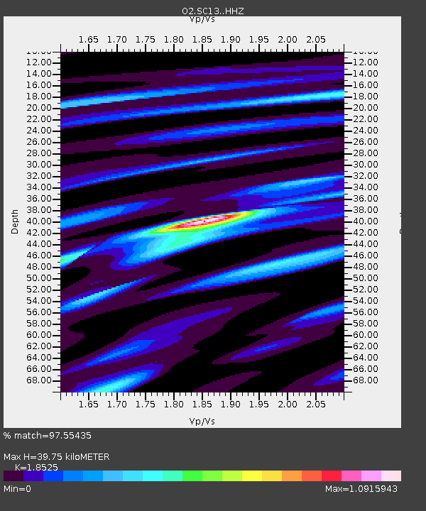
| Estimated Moho Depth: |
39.75 km |
| Estimated Crust Vp/Vs: |
1.85 |
| Assumed Crust Vp: |
6.426 km/s |
| Estimated Crust Vs: |
3.469 km/s |
| Estimated Crust Poisson's Ratio: |
0.29 |
|
| Radial Match: |
97.55435 % |
| Radial Bump: |
325 |
| Transverse Match: |
92.879105 % |
| Transverse Bump: |
400 |
| SOD ConfigId: |
25131211 |
| Insert Time: |
2021-08-28 12:16:59.267 +0000 |
| GWidth: |
2.5 |
| Max Bumps: |
400 |
| Tol: |
0.001 |
|

Signal To Noise
| Channel | StoN | STA | LTA |
| O2:SC13: :HHZ:20210814T12:05:35.584989Z | 16.64 | 1.5566148E-6 | 9.354657E-8 |
| O2:SC13: :HHN:20210814T12:05:35.584989Z | 5.153255 | 3.4654786E-7 | 6.7248344E-8 |
| O2:SC13: :HHE:20210814T12:05:35.584989Z | 8.414379 | 8.5819136E-7 | 1.01991056E-7 |
| Arrivals |
| Ps | 5.6 SECOND |
| PpPs | 17 SECOND |
| PsPs/PpSs | 22 SECOND |


