You are here: Home > Network List > O2 - Oklahoma Consolidated Temporary Seismic Networks Stations List
> Station SC15 Hammon, Oklahoma, USA > Earthquake Result Viewer
SC15 Hammon, Oklahoma, USA - Earthquake Result Viewer
| Earthquake location: |
Alaska Peninsula |
| Earthquake latitude/longitude: |
55.2/-157.7 |
| Earthquake time(UTC): |
2021/08/14 (226) 11:57:42 GMT |
| Earthquake Depth: |
4.8 km |
| Earthquake Magnitude: |
6.4 ml |
| Earthquake Catalog/Contributor: |
NEIC PDE/ak |
|
| Network: |
O2 Oklahoma Consolidated Temporary Seismic Networks |
| Station: |
SC15 Hammon, Oklahoma, USA |
| Lat/Lon: |
35.61 N/99.50 W |
| Elevation: |
550 m |
|
| Distance: |
43.9 deg |
| Az: |
91.648 deg |
| Baz: |
315.363 deg |
| Ray Param: |
0.07229406 |
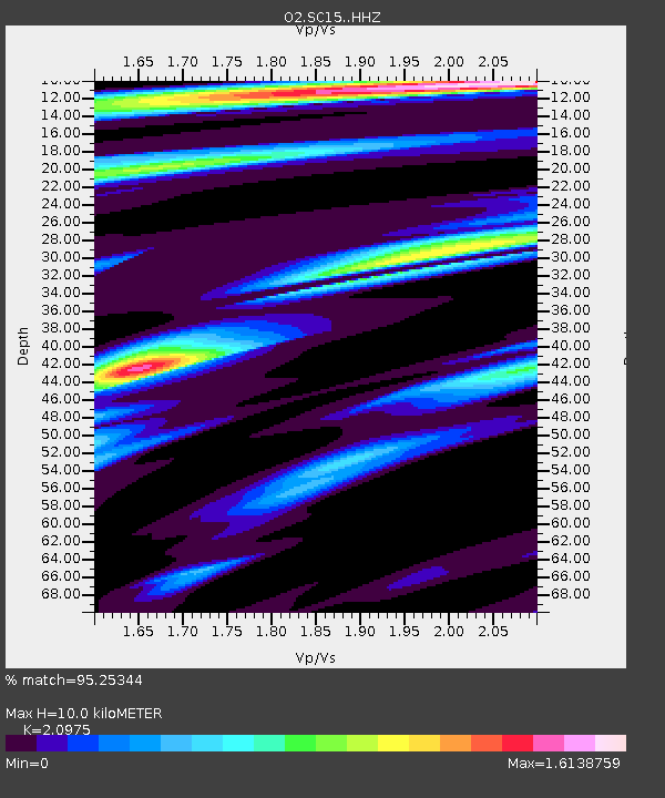
| Estimated Moho Depth: |
10.0 km |
| Estimated Crust Vp/Vs: |
2.10 |
| Assumed Crust Vp: |
6.315 km/s |
| Estimated Crust Vs: |
3.011 km/s |
| Estimated Crust Poisson's Ratio: |
0.35 |
|
| Radial Match: |
95.25344 % |
| Radial Bump: |
400 |
| Transverse Match: |
80.528725 % |
| Transverse Bump: |
400 |
| SOD ConfigId: |
25131211 |
| Insert Time: |
2021-08-28 12:17:02.154 +0000 |
| GWidth: |
2.5 |
| Max Bumps: |
400 |
| Tol: |
0.001 |
|

Signal To Noise
| Channel | StoN | STA | LTA |
| O2:SC15: :HHZ:20210814T12:05:18.955015Z | 13.476425 | 3.4752268E-6 | 2.5787455E-7 |
| O2:SC15: :HHN:20210814T12:05:18.955015Z | 6.421059 | 1.1930208E-6 | 1.8579814E-7 |
| O2:SC15: :HHE:20210814T12:05:18.955015Z | 6.3757577 | 1.1451474E-6 | 1.7960963E-7 |
| Arrivals |
| Ps | 1.8 SECOND |
| PpPs | 4.7 SECOND |
| PsPs/PpSs | 6.5 SECOND |


