You are here: Home > Network List > O2 - Oklahoma Consolidated Temporary Seismic Networks Stations List
> Station TUTT Tuttle, Oklahoma, USA > Earthquake Result Viewer
TUTT Tuttle, Oklahoma, USA - Earthquake Result Viewer
| Earthquake location: |
Alaska Peninsula |
| Earthquake latitude/longitude: |
55.2/-157.7 |
| Earthquake time(UTC): |
2021/08/14 (226) 11:57:42 GMT |
| Earthquake Depth: |
4.8 km |
| Earthquake Magnitude: |
6.4 ml |
| Earthquake Catalog/Contributor: |
NEIC PDE/ak |
|
| Network: |
O2 Oklahoma Consolidated Temporary Seismic Networks |
| Station: |
TUTT Tuttle, Oklahoma, USA |
| Lat/Lon: |
35.24 N/97.76 W |
| Elevation: |
407 m |
|
| Distance: |
45.1 deg |
| Az: |
90.566 deg |
| Baz: |
315.598 deg |
| Ray Param: |
0.07150841 |
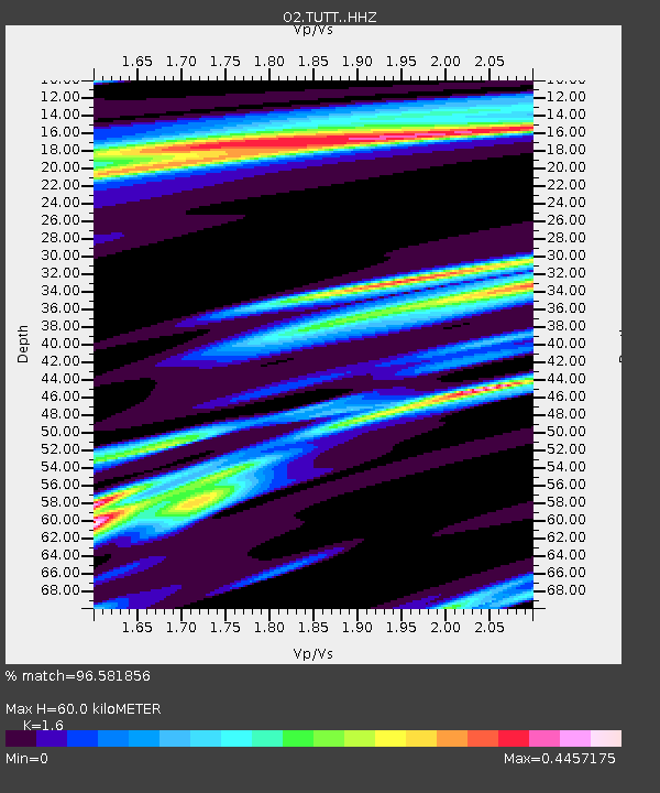
| Estimated Moho Depth: |
60.0 km |
| Estimated Crust Vp/Vs: |
1.60 |
| Assumed Crust Vp: |
6.426 km/s |
| Estimated Crust Vs: |
4.016 km/s |
| Estimated Crust Poisson's Ratio: |
0.18 |
|
| Radial Match: |
96.581856 % |
| Radial Bump: |
280 |
| Transverse Match: |
92.04511 % |
| Transverse Bump: |
400 |
| SOD ConfigId: |
25131211 |
| Insert Time: |
2021-08-28 12:17:12.587 +0000 |
| GWidth: |
2.5 |
| Max Bumps: |
400 |
| Tol: |
0.001 |
|

Signal To Noise
| Channel | StoN | STA | LTA |
| O2:TUTT: :HHZ:20210814T12:05:29.024991Z | 9.99882 | 1.5131151E-6 | 1.5132936E-7 |
| O2:TUTT: :HHN:20210814T12:05:29.024991Z | 1.6940277 | 3.4547946E-7 | 2.0393968E-7 |
| O2:TUTT: :HHE:20210814T12:05:29.024991Z | 6.879995 | 1.0384392E-6 | 1.5093606E-7 |
| Arrivals |
| Ps | 6.0 SECOND |
| PpPs | 23 SECOND |
| PsPs/PpSs | 29 SECOND |


