You are here: Home > Network List > OH - Ohio Seismic Network Stations List
> Station SLSO Stonelick State Park Ohio > Earthquake Result Viewer
SLSO Stonelick State Park Ohio - Earthquake Result Viewer
| Earthquake location: |
Alaska Peninsula |
| Earthquake latitude/longitude: |
55.2/-157.7 |
| Earthquake time(UTC): |
2021/08/14 (226) 11:57:42 GMT |
| Earthquake Depth: |
4.8 km |
| Earthquake Magnitude: |
6.4 ml |
| Earthquake Catalog/Contributor: |
NEIC PDE/ak |
|
| Network: |
OH Ohio Seismic Network |
| Station: |
SLSO Stonelick State Park Ohio |
| Lat/Lon: |
39.22 N/84.06 W |
| Elevation: |
272 m |
|
| Distance: |
50.1 deg |
| Az: |
76.316 deg |
| Baz: |
314.238 deg |
| Ray Param: |
0.06829719 |
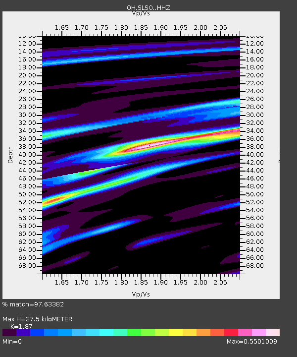
| Estimated Moho Depth: |
37.5 km |
| Estimated Crust Vp/Vs: |
1.87 |
| Assumed Crust Vp: |
6.498 km/s |
| Estimated Crust Vs: |
3.475 km/s |
| Estimated Crust Poisson's Ratio: |
0.30 |
|
| Radial Match: |
97.63382 % |
| Radial Bump: |
179 |
| Transverse Match: |
88.207634 % |
| Transverse Bump: |
400 |
| SOD ConfigId: |
25131211 |
| Insert Time: |
2021-08-28 12:17:30.823 +0000 |
| GWidth: |
2.5 |
| Max Bumps: |
400 |
| Tol: |
0.001 |
|

Signal To Noise
| Channel | StoN | STA | LTA |
| OH:SLSO: :HHZ:20210814T12:06:07.640012Z | 21.25008 | 3.3849894E-6 | 1.5929301E-7 |
| OH:SLSO: :HHN:20210814T12:06:07.640012Z | 14.839668 | 1.2423317E-6 | 8.371695E-8 |
| OH:SLSO: :HHE:20210814T12:06:07.640012Z | 10.986303 | 1.5392144E-6 | 1.4010304E-7 |
| Arrivals |
| Ps | 5.3 SECOND |
| PpPs | 16 SECOND |
| PsPs/PpSs | 21 SECOND |


