You are here: Home > Network List > OK - Oklahoma Seismic Network Stations List
> Station CROK Carrier, Oklahoma > Earthquake Result Viewer
CROK Carrier, Oklahoma - Earthquake Result Viewer
| Earthquake location: |
Alaska Peninsula |
| Earthquake latitude/longitude: |
55.2/-157.7 |
| Earthquake time(UTC): |
2021/08/14 (226) 11:57:42 GMT |
| Earthquake Depth: |
4.8 km |
| Earthquake Magnitude: |
6.4 ml |
| Earthquake Catalog/Contributor: |
NEIC PDE/ak |
|
| Network: |
OK Oklahoma Seismic Network |
| Station: |
CROK Carrier, Oklahoma |
| Lat/Lon: |
36.50 N/97.98 W |
| Elevation: |
403 m |
|
| Distance: |
44.1 deg |
| Az: |
89.483 deg |
| Baz: |
314.695 deg |
| Ray Param: |
0.072153114 |
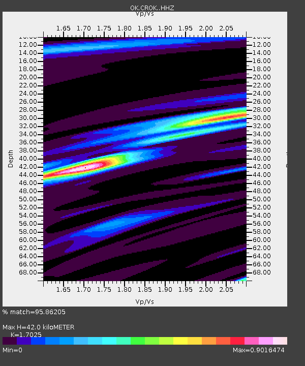
| Estimated Moho Depth: |
42.0 km |
| Estimated Crust Vp/Vs: |
1.70 |
| Assumed Crust Vp: |
6.483 km/s |
| Estimated Crust Vs: |
3.808 km/s |
| Estimated Crust Poisson's Ratio: |
0.24 |
|
| Radial Match: |
95.86205 % |
| Radial Bump: |
266 |
| Transverse Match: |
71.72136 % |
| Transverse Bump: |
400 |
| SOD ConfigId: |
25131211 |
| Insert Time: |
2021-08-28 12:17:38.058 +0000 |
| GWidth: |
2.5 |
| Max Bumps: |
400 |
| Tol: |
0.001 |
|

Signal To Noise
| Channel | StoN | STA | LTA |
| OK:CROK: :HHZ:20210814T12:05:20.839994Z | 11.065298 | 1.4239989E-6 | 1.2869052E-7 |
| OK:CROK: :HHN:20210814T12:05:20.839994Z | 3.464976 | 5.1210935E-7 | 1.4779593E-7 |
| OK:CROK: :HHE:20210814T12:05:20.839994Z | 4.925841 | 7.5072995E-7 | 1.5240644E-7 |
| Arrivals |
| Ps | 4.9 SECOND |
| PpPs | 16 SECOND |
| PsPs/PpSs | 21 SECOND |


