You are here: Home > Network List > PR - Puerto Rico Seismic Network (PRSN) & Puerto Rico Strong Motion Program (PRSMP) Stations List
> Station MTP MTP > Earthquake Result Viewer
MTP MTP - Earthquake Result Viewer
| Earthquake location: |
Alaska Peninsula |
| Earthquake latitude/longitude: |
55.2/-157.7 |
| Earthquake time(UTC): |
2021/08/14 (226) 11:57:42 GMT |
| Earthquake Depth: |
4.8 km |
| Earthquake Magnitude: |
6.4 ml |
| Earthquake Catalog/Contributor: |
NEIC PDE/ak |
|
| Network: |
PR Puerto Rico Seismic Network (PRSN) & Puerto Rico Strong Motion Program (PRSMP) |
| Station: |
MTP MTP |
| Lat/Lon: |
18.10 N/65.55 W |
| Elevation: |
192 m |
|
| Distance: |
76.5 deg |
| Az: |
77.763 deg |
| Baz: |
323.948 deg |
| Ray Param: |
0.050937302 |
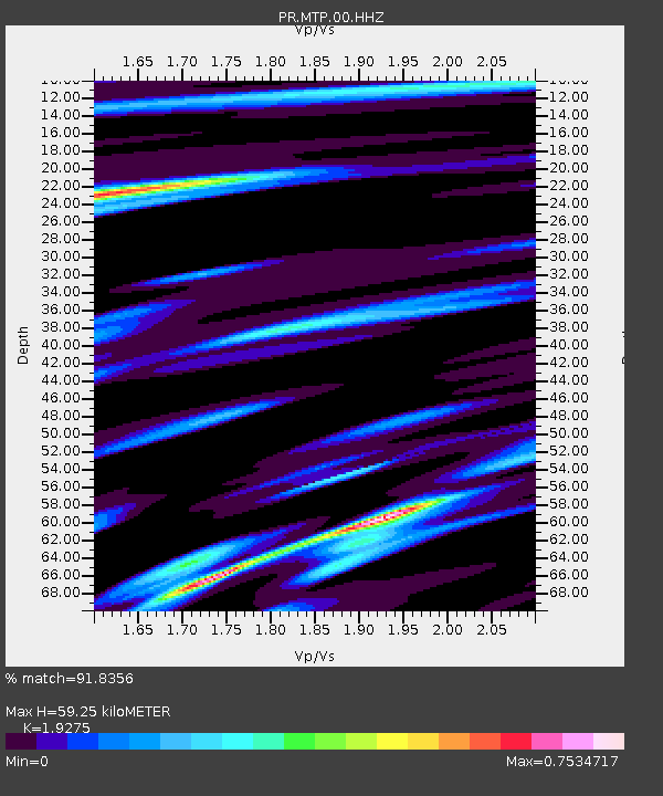
| Estimated Moho Depth: |
59.25 km |
| Estimated Crust Vp/Vs: |
1.93 |
| Assumed Crust Vp: |
5.14 km/s |
| Estimated Crust Vs: |
2.667 km/s |
| Estimated Crust Poisson's Ratio: |
0.32 |
|
| Radial Match: |
91.8356 % |
| Radial Bump: |
400 |
| Transverse Match: |
89.8706 % |
| Transverse Bump: |
400 |
| SOD ConfigId: |
25131211 |
| Insert Time: |
2021-08-28 12:19:46.165 +0000 |
| GWidth: |
2.5 |
| Max Bumps: |
400 |
| Tol: |
0.001 |
|

Signal To Noise
| Channel | StoN | STA | LTA |
| PR:MTP:00:HHZ:20210814T12:09:02.530027Z | 28.81605 | 3.8060646E-6 | 1.3208141E-7 |
| PR:MTP:00:HH1:20210814T12:09:02.530027Z | 7.1177335 | 1.1578129E-6 | 1.6266594E-7 |
| PR:MTP:00:HH2:20210814T12:09:02.530027Z | 6.139585 | 7.1714686E-7 | 1.1680706E-7 |
| Arrivals |
| Ps | 11 SECOND |
| PpPs | 33 SECOND |
| PsPs/PpSs | 44 SECOND |


