You are here: Home > Network List > PR - Puerto Rico Seismic Network (PRSN) & Puerto Rico Strong Motion Program (PRSMP) Stations List
> Station PRSN PRSN > Earthquake Result Viewer
PRSN PRSN - Earthquake Result Viewer
| Earthquake location: |
Alaska Peninsula |
| Earthquake latitude/longitude: |
55.2/-157.7 |
| Earthquake time(UTC): |
2021/08/14 (226) 11:57:42 GMT |
| Earthquake Depth: |
4.8 km |
| Earthquake Magnitude: |
6.4 ml |
| Earthquake Catalog/Contributor: |
NEIC PDE/ak |
|
| Network: |
PR Puerto Rico Seismic Network (PRSN) & Puerto Rico Strong Motion Program (PRSMP) |
| Station: |
PRSN PRSN |
| Lat/Lon: |
18.22 N/67.14 W |
| Elevation: |
27 m |
|
| Distance: |
75.6 deg |
| Az: |
78.949 deg |
| Baz: |
323.741 deg |
| Ray Param: |
0.051604476 |
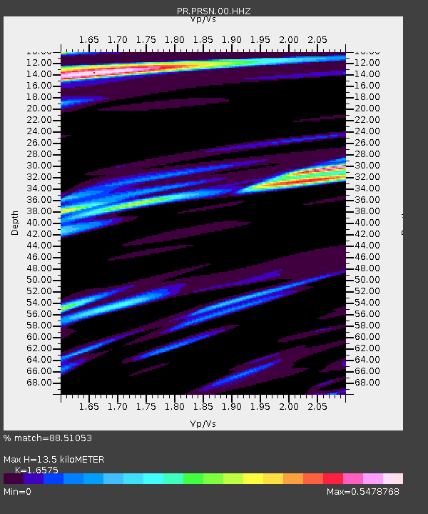
| Estimated Moho Depth: |
13.5 km |
| Estimated Crust Vp/Vs: |
1.66 |
| Assumed Crust Vp: |
5.14 km/s |
| Estimated Crust Vs: |
3.101 km/s |
| Estimated Crust Poisson's Ratio: |
0.21 |
|
| Radial Match: |
88.51053 % |
| Radial Bump: |
400 |
| Transverse Match: |
90.25563 % |
| Transverse Bump: |
400 |
| SOD ConfigId: |
25131211 |
| Insert Time: |
2021-08-28 12:19:49.609 +0000 |
| GWidth: |
2.5 |
| Max Bumps: |
400 |
| Tol: |
0.001 |
|

Signal To Noise
| Channel | StoN | STA | LTA |
| PR:PRSN:00:HHZ:20210814T12:08:56.909971Z | 15.376598 | 3.5916532E-6 | 2.3357917E-7 |
| PR:PRSN:00:HH1:20210814T12:08:56.909971Z | 2.6878927 | 7.9687794E-7 | 2.964694E-7 |
| PR:PRSN:00:HH2:20210814T12:08:56.909971Z | 3.4828465 | 8.9429204E-7 | 2.5677045E-7 |
| Arrivals |
| Ps | 1.8 SECOND |
| PpPs | 6.8 SECOND |
| PsPs/PpSs | 8.6 SECOND |


