You are here: Home > Network List > SB - UC Santa Barbara Engineering Seismology Network () Stations List
> Station VAFB2 Taft Rd, Vandenberg AFB, CA, USA > Earthquake Result Viewer
VAFB2 Taft Rd, Vandenberg AFB, CA, USA - Earthquake Result Viewer
| Earthquake location: |
Alaska Peninsula |
| Earthquake latitude/longitude: |
55.2/-157.7 |
| Earthquake time(UTC): |
2021/08/14 (226) 11:57:42 GMT |
| Earthquake Depth: |
4.8 km |
| Earthquake Magnitude: |
6.4 ml |
| Earthquake Catalog/Contributor: |
NEIC PDE/ak |
|
| Network: |
SB UC Santa Barbara Engineering Seismology Network () |
| Station: |
VAFB2 Taft Rd, Vandenberg AFB, CA, USA |
| Lat/Lon: |
34.84 N/120.58 W |
| Elevation: |
91 m |
|
| Distance: |
32.7 deg |
| Az: |
113.105 deg |
| Baz: |
320.169 deg |
| Ray Param: |
0.078575574 |
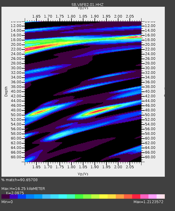
| Estimated Moho Depth: |
16.25 km |
| Estimated Crust Vp/Vs: |
2.10 |
| Assumed Crust Vp: |
6.183 km/s |
| Estimated Crust Vs: |
2.948 km/s |
| Estimated Crust Poisson's Ratio: |
0.35 |
|
| Radial Match: |
90.65708 % |
| Radial Bump: |
350 |
| Transverse Match: |
75.62197 % |
| Transverse Bump: |
400 |
| SOD ConfigId: |
25131211 |
| Insert Time: |
2021-08-28 12:20:44.783 +0000 |
| GWidth: |
2.5 |
| Max Bumps: |
400 |
| Tol: |
0.001 |
|

Signal To Noise
| Channel | StoN | STA | LTA |
| SB:VAFB2:01:HHZ:20210814T12:03:44.920011Z | 16.118876 | 8.451735E-6 | 5.2433774E-7 |
| SB:VAFB2:01:HHN:20210814T12:03:44.920011Z | 8.716602 | 4.2146603E-6 | 4.83521E-7 |
| SB:VAFB2:01:HHE:20210814T12:03:44.920011Z | 8.115909 | 4.1409517E-6 | 5.1022647E-7 |
| Arrivals |
| Ps | 3.1 SECOND |
| PpPs | 7.7 SECOND |
| PsPs/PpSs | 11 SECOND |


