You are here: Home > Network List > TA - USArray Transportable Network (new EarthScope stations) Stations List
> Station M65A Busby, Falmouth, MA, USA > Earthquake Result Viewer
M65A Busby, Falmouth, MA, USA - Earthquake Result Viewer
| Earthquake location: |
Alaska Peninsula |
| Earthquake latitude/longitude: |
55.2/-157.7 |
| Earthquake time(UTC): |
2021/08/14 (226) 11:57:42 GMT |
| Earthquake Depth: |
4.8 km |
| Earthquake Magnitude: |
6.4 ml |
| Earthquake Catalog/Contributor: |
NEIC PDE/ak |
|
| Network: |
TA USArray Transportable Network (new EarthScope stations) |
| Station: |
M65A Busby, Falmouth, MA, USA |
| Lat/Lon: |
41.56 N/70.65 W |
| Elevation: |
22 m |
|
| Distance: |
55.7 deg |
| Az: |
65.155 deg |
| Baz: |
316.163 deg |
| Ray Param: |
0.06465072 |
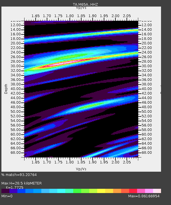
| Estimated Moho Depth: |
28.5 km |
| Estimated Crust Vp/Vs: |
1.77 |
| Assumed Crust Vp: |
6.472 km/s |
| Estimated Crust Vs: |
3.651 km/s |
| Estimated Crust Poisson's Ratio: |
0.27 |
|
| Radial Match: |
93.20764 % |
| Radial Bump: |
374 |
| Transverse Match: |
71.54148 % |
| Transverse Bump: |
400 |
| SOD ConfigId: |
25131211 |
| Insert Time: |
2021-08-28 12:21:06.927 +0000 |
| GWidth: |
2.5 |
| Max Bumps: |
400 |
| Tol: |
0.001 |
|

Signal To Noise
| Channel | StoN | STA | LTA |
| TA:M65A: :HHZ:20210814T12:06:48.789976Z | 12.151266 | 4.7587896E-6 | 3.916291E-7 |
| TA:M65A: :HHN:20210814T12:06:48.789976Z | 2.4169998 | 1.848752E-6 | 7.648954E-7 |
| TA:M65A: :HHE:20210814T12:06:48.789976Z | 3.0433586 | 1.6677733E-6 | 5.480042E-7 |
| Arrivals |
| Ps | 3.6 SECOND |
| PpPs | 12 SECOND |
| PsPs/PpSs | 15 SECOND |


