You are here: Home > Network List > TX - Texas Seismological Network Stations List
> Station EF02 Christine > Earthquake Result Viewer
EF02 Christine - Earthquake Result Viewer
| Earthquake location: |
Alaska Peninsula |
| Earthquake latitude/longitude: |
55.2/-157.7 |
| Earthquake time(UTC): |
2021/08/14 (226) 11:57:42 GMT |
| Earthquake Depth: |
4.8 km |
| Earthquake Magnitude: |
6.4 ml |
| Earthquake Catalog/Contributor: |
NEIC PDE/ak |
|
| Network: |
TX Texas Seismological Network |
| Station: |
EF02 Christine |
| Lat/Lon: |
28.78 N/98.53 W |
| Elevation: |
96 m |
|
| Distance: |
49.4 deg |
| Az: |
97.14 deg |
| Baz: |
319.654 deg |
| Ray Param: |
0.068727255 |
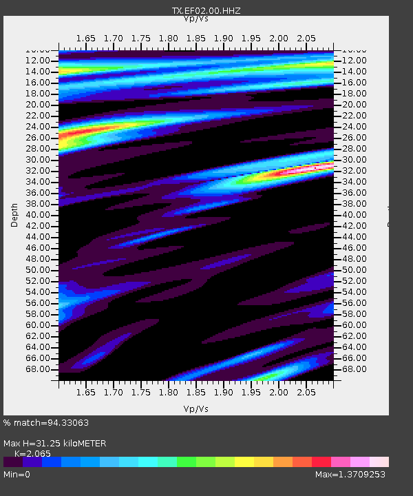
| Estimated Moho Depth: |
31.25 km |
| Estimated Crust Vp/Vs: |
2.07 |
| Assumed Crust Vp: |
6.347 km/s |
| Estimated Crust Vs: |
3.074 km/s |
| Estimated Crust Poisson's Ratio: |
0.35 |
|
| Radial Match: |
94.33063 % |
| Radial Bump: |
400 |
| Transverse Match: |
87.44809 % |
| Transverse Bump: |
400 |
| SOD ConfigId: |
25131211 |
| Insert Time: |
2021-08-28 12:21:45.439 +0000 |
| GWidth: |
2.5 |
| Max Bumps: |
400 |
| Tol: |
0.001 |
|

Signal To Noise
| Channel | StoN | STA | LTA |
| TX:EF02:00:HHZ:20210814T12:06:02.649991Z | 16.561287 | 2.4700746E-6 | 1.491475E-7 |
| TX:EF02:00:HHN:20210814T12:06:02.649991Z | 3.7624385 | 9.975593E-7 | 2.6513638E-7 |
| TX:EF02:00:HHE:20210814T12:06:02.649991Z | 3.8169713 | 1.3784971E-6 | 3.6114946E-7 |
| Arrivals |
| Ps | 5.5 SECOND |
| PpPs | 14 SECOND |
| PsPs/PpSs | 20 SECOND |


