You are here: Home > Network List > TX - Texas Seismological Network Stations List
> Station HBVL Hebbronville > Earthquake Result Viewer
HBVL Hebbronville - Earthquake Result Viewer
| Earthquake location: |
Alaska Peninsula |
| Earthquake latitude/longitude: |
55.2/-157.7 |
| Earthquake time(UTC): |
2021/08/14 (226) 11:57:42 GMT |
| Earthquake Depth: |
4.8 km |
| Earthquake Magnitude: |
6.4 ml |
| Earthquake Catalog/Contributor: |
NEIC PDE/ak |
|
| Network: |
TX Texas Seismological Network |
| Station: |
HBVL Hebbronville |
| Lat/Lon: |
27.06 N/98.67 W |
| Elevation: |
155 m |
|
| Distance: |
50.7 deg |
| Az: |
98.687 deg |
| Baz: |
320.583 deg |
| Ray Param: |
0.067914195 |
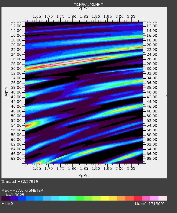
| Estimated Moho Depth: |
27.0 km |
| Estimated Crust Vp/Vs: |
1.80 |
| Assumed Crust Vp: |
6.096 km/s |
| Estimated Crust Vs: |
3.382 km/s |
| Estimated Crust Poisson's Ratio: |
0.28 |
|
| Radial Match: |
82.57919 % |
| Radial Bump: |
400 |
| Transverse Match: |
74.71347 % |
| Transverse Bump: |
400 |
| SOD ConfigId: |
25131211 |
| Insert Time: |
2021-08-28 12:22:03.816 +0000 |
| GWidth: |
2.5 |
| Max Bumps: |
400 |
| Tol: |
0.001 |
|

Signal To Noise
| Channel | StoN | STA | LTA |
| TX:HBVL:00:HHZ:20210814T12:06:11.969999Z | 18.646553 | 3.3921815E-6 | 1.8192003E-7 |
| TX:HBVL:00:HH1:20210814T12:06:11.969999Z | 0.47877815 | 1.7987313E-7 | 3.7569203E-7 |
| TX:HBVL:00:HH2:20210814T12:06:11.969999Z | 2.7026668 | 7.4838385E-7 | 2.769057E-7 |
| Arrivals |
| Ps | 3.7 SECOND |
| PpPs | 12 SECOND |
| PsPs/PpSs | 16 SECOND |


