You are here: Home > Network List > TX - Texas Seismological Network Stations List
> Station MLDN Muldoon > Earthquake Result Viewer
MLDN Muldoon - Earthquake Result Viewer
| Earthquake location: |
Alaska Peninsula |
| Earthquake latitude/longitude: |
55.2/-157.7 |
| Earthquake time(UTC): |
2021/08/14 (226) 11:57:42 GMT |
| Earthquake Depth: |
4.8 km |
| Earthquake Magnitude: |
6.4 ml |
| Earthquake Catalog/Contributor: |
NEIC PDE/ak |
|
| Network: |
TX Texas Seismological Network |
| Station: |
MLDN Muldoon |
| Lat/Lon: |
29.78 N/97.07 W |
| Elevation: |
106 m |
|
| Distance: |
49.5 deg |
| Az: |
95.004 deg |
| Baz: |
318.978 deg |
| Ray Param: |
0.068682395 |
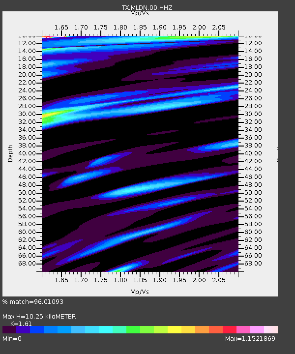
| Estimated Moho Depth: |
10.25 km |
| Estimated Crust Vp/Vs: |
1.61 |
| Assumed Crust Vp: |
5.78 km/s |
| Estimated Crust Vs: |
3.59 km/s |
| Estimated Crust Poisson's Ratio: |
0.19 |
|
| Radial Match: |
96.01093 % |
| Radial Bump: |
400 |
| Transverse Match: |
77.8722 % |
| Transverse Bump: |
400 |
| SOD ConfigId: |
25131211 |
| Insert Time: |
2021-08-28 12:22:16.250 +0000 |
| GWidth: |
2.5 |
| Max Bumps: |
400 |
| Tol: |
0.001 |
|

Signal To Noise
| Channel | StoN | STA | LTA |
| TX:MLDN:00:HHZ:20210814T12:06:03.20001Z | 19.966246 | 2.5467991E-6 | 1.2755524E-7 |
| TX:MLDN:00:HH1:20210814T12:06:03.20001Z | 7.0470266 | 1.7323529E-6 | 2.458275E-7 |
| TX:MLDN:00:HH2:20210814T12:06:03.20001Z | 1.9542804 | 4.4994863E-7 | 2.302375E-7 |
| Arrivals |
| Ps | 1.1 SECOND |
| PpPs | 4.4 SECOND |
| PsPs/PpSs | 5.5 SECOND |


