You are here: Home > Network List > TX - Texas Seismological Network Stations List
> Station PB11 China Draw > Earthquake Result Viewer
PB11 China Draw - Earthquake Result Viewer
| Earthquake location: |
Alaska Peninsula |
| Earthquake latitude/longitude: |
55.2/-157.7 |
| Earthquake time(UTC): |
2021/08/14 (226) 11:57:42 GMT |
| Earthquake Depth: |
4.8 km |
| Earthquake Magnitude: |
6.4 ml |
| Earthquake Catalog/Contributor: |
NEIC PDE/ak |
|
| Network: |
TX Texas Seismological Network |
| Station: |
PB11 China Draw |
| Lat/Lon: |
31.94 N/104.03 W |
| Elevation: |
915 m |
|
| Distance: |
43.9 deg |
| Az: |
99.234 deg |
| Baz: |
318.322 deg |
| Ray Param: |
0.07223659 |
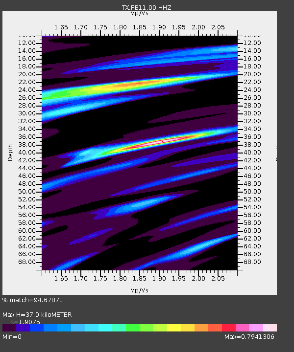
| Estimated Moho Depth: |
37.0 km |
| Estimated Crust Vp/Vs: |
1.91 |
| Assumed Crust Vp: |
6.361 km/s |
| Estimated Crust Vs: |
3.335 km/s |
| Estimated Crust Poisson's Ratio: |
0.31 |
|
| Radial Match: |
94.67871 % |
| Radial Bump: |
400 |
| Transverse Match: |
84.51365 % |
| Transverse Bump: |
400 |
| SOD ConfigId: |
25131211 |
| Insert Time: |
2021-08-28 12:22:30.546 +0000 |
| GWidth: |
2.5 |
| Max Bumps: |
400 |
| Tol: |
0.001 |
|

Signal To Noise
| Channel | StoN | STA | LTA |
| TX:PB11:00:HHZ:20210814T12:05:19.649991Z | 20.854864 | 2.7511542E-6 | 1.3191907E-7 |
| TX:PB11:00:HH1:20210814T12:05:19.649991Z | 11.036802 | 9.933E-7 | 8.999889E-8 |
| TX:PB11:00:HH2:20210814T12:05:19.649991Z | 10.659635 | 8.374301E-7 | 7.856086E-8 |
| Arrivals |
| Ps | 5.6 SECOND |
| PpPs | 16 SECOND |
| PsPs/PpSs | 22 SECOND |


