You are here: Home > Network List > TX - Texas Seismological Network Stations List
> Station SN08 Arah > Earthquake Result Viewer
SN08 Arah - Earthquake Result Viewer
| Earthquake location: |
Alaska Peninsula |
| Earthquake latitude/longitude: |
55.2/-157.7 |
| Earthquake time(UTC): |
2021/08/14 (226) 11:57:42 GMT |
| Earthquake Depth: |
4.8 km |
| Earthquake Magnitude: |
6.4 ml |
| Earthquake Catalog/Contributor: |
NEIC PDE/ak |
|
| Network: |
TX Texas Seismological Network |
| Station: |
SN08 Arah |
| Lat/Lon: |
32.78 N/101.06 W |
| Elevation: |
741 m |
|
| Distance: |
45.0 deg |
| Az: |
95.761 deg |
| Baz: |
317.428 deg |
| Ray Param: |
0.071580596 |
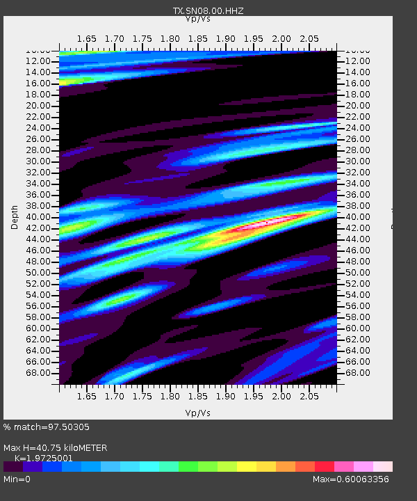
| Estimated Moho Depth: |
40.75 km |
| Estimated Crust Vp/Vs: |
1.97 |
| Assumed Crust Vp: |
6.426 km/s |
| Estimated Crust Vs: |
3.258 km/s |
| Estimated Crust Poisson's Ratio: |
0.33 |
|
| Radial Match: |
97.50305 % |
| Radial Bump: |
270 |
| Transverse Match: |
91.29169 % |
| Transverse Bump: |
400 |
| SOD ConfigId: |
25131211 |
| Insert Time: |
2021-08-28 12:23:02.763 +0000 |
| GWidth: |
2.5 |
| Max Bumps: |
400 |
| Tol: |
0.001 |
|

Signal To Noise
| Channel | StoN | STA | LTA |
| TX:SN08:00:HHZ:20210814T12:05:28.124998Z | 17.617462 | 2.0117711E-6 | 1.1419188E-7 |
| TX:SN08:00:HH1:20210814T12:05:28.124998Z | 5.7042193 | 6.268596E-7 | 1.09894025E-7 |
| TX:SN08:00:HH2:20210814T12:05:28.124998Z | 9.508597 | 1.0569643E-6 | 1.111588E-7 |
| Arrivals |
| Ps | 6.5 SECOND |
| PpPs | 18 SECOND |
| PsPs/PpSs | 24 SECOND |


