You are here: Home > Network List > TX - Texas Seismological Network Stations List
> Station VHRN Van Horn > Earthquake Result Viewer
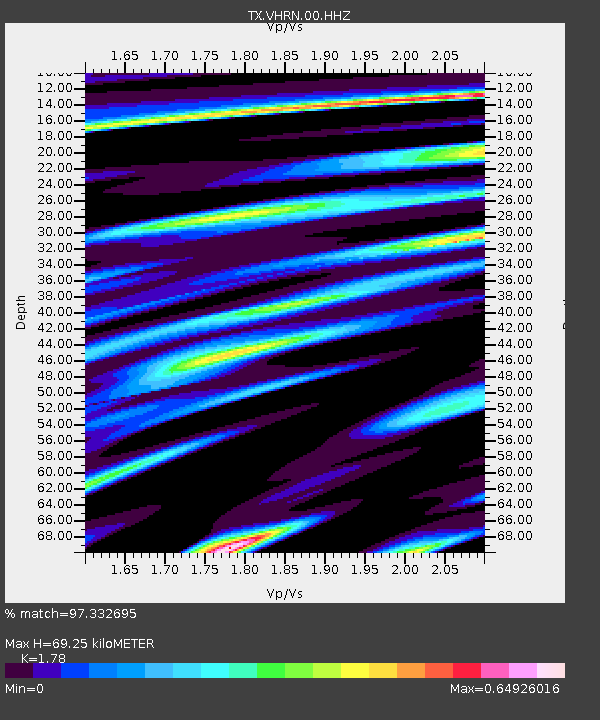
VHRN Van Horn - Earthquake Result Viewer
| Earthquake location: |
Alaska Peninsula |
| Earthquake latitude/longitude: |
55.2/-157.7 |
| Earthquake time(UTC): |
2021/08/14 (226) 11:57:42 GMT |
| Earthquake Depth: |
4.8 km |
| Earthquake Magnitude: |
6.4 ml |
| Earthquake Catalog/Contributor: |
NEIC PDE/ak |
|
| Network: |
TX Texas Seismological Network |
| Station: |
VHRN Van Horn |
| Lat/Lon: |
30.79 N/104.99 W |
| Elevation: |
1342 m |
|
| Distance: |
44.3 deg |
| Az: |
101.197 deg |
| Baz: |
319.24 deg |
| Ray Param: |
0.07204962 |
| Estimated Moho Depth: |
69.25 km |
| Estimated Crust Vp/Vs: |
1.78 |
| Assumed Crust Vp: |
6.361 km/s |
| Estimated Crust Vs: |
3.573 km/s |
| Estimated Crust Poisson's Ratio: |
0.27 |
|
| Radial Match: |
97.332695 % |
| Radial Bump: |
381 |
| Transverse Match: |
76.538376 % |
| Transverse Bump: |
400 |
| SOD ConfigId: |
25131211 |
| Insert Time: |
2021-08-28 12:23:08.081 +0000 |
| GWidth: |
2.5 |
| Max Bumps: |
400 |
| Tol: |
0.001 |
|

Signal To Noise
| Channel | StoN | STA | LTA |
| TX:VHRN:00:HHZ:20210814T12:05:22.255002Z | 31.417944 | 3.7908035E-6 | 1.2065728E-7 |
| TX:VHRN:00:HH1:20210814T12:05:22.255002Z | 20.135017 | 1.9142742E-6 | 9.507189E-8 |
| TX:VHRN:00:HH2:20210814T12:05:22.255002Z | 8.888294 | 1.0684093E-6 | 1.202041E-7 |
| Arrivals |
| Ps | 9.0 SECOND |
| PpPs | 28 SECOND |
| PsPs/PpSs | 37 SECOND |


