You are here: Home > Network List > US - United States National Seismic Network Stations List
> Station AGMN Agassiz National Wildlife Refuge, Minnesota, USA > Earthquake Result Viewer
AGMN Agassiz National Wildlife Refuge, Minnesota, USA - Earthquake Result Viewer
| Earthquake location: |
Alaska Peninsula |
| Earthquake latitude/longitude: |
55.2/-157.7 |
| Earthquake time(UTC): |
2021/08/14 (226) 11:57:42 GMT |
| Earthquake Depth: |
4.8 km |
| Earthquake Magnitude: |
6.4 ml |
| Earthquake Catalog/Contributor: |
NEIC PDE/ak |
|
| Network: |
US United States National Seismic Network |
| Station: |
AGMN Agassiz National Wildlife Refuge, Minnesota, USA |
| Lat/Lon: |
48.30 N/95.86 W |
| Elevation: |
351 m |
|
| Distance: |
37.8 deg |
| Az: |
74.065 deg |
| Baz: |
304.43 deg |
| Ray Param: |
0.075975455 |
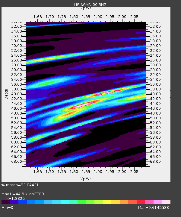
| Estimated Moho Depth: |
44.5 km |
| Estimated Crust Vp/Vs: |
1.83 |
| Assumed Crust Vp: |
6.419 km/s |
| Estimated Crust Vs: |
3.503 km/s |
| Estimated Crust Poisson's Ratio: |
0.29 |
|
| Radial Match: |
93.84431 % |
| Radial Bump: |
193 |
| Transverse Match: |
70.69326 % |
| Transverse Bump: |
400 |
| SOD ConfigId: |
25131211 |
| Insert Time: |
2021-08-28 12:23:17.951 +0000 |
| GWidth: |
2.5 |
| Max Bumps: |
400 |
| Tol: |
0.001 |
|

Signal To Noise
| Channel | StoN | STA | LTA |
| US:AGMN:00:BHZ:20210814T12:04:28.649991Z | 24.92567 | 2.5607035E-6 | 1.0273359E-7 |
| US:AGMN:00:BH1:20210814T12:04:28.649991Z | 10.299115 | 1.039476E-6 | 1.0092868E-7 |
| US:AGMN:00:BH2:20210814T12:04:28.649991Z | 6.850271 | 1.4646143E-6 | 2.1380384E-7 |
| Arrivals |
| Ps | 6.2 SECOND |
| PpPs | 18 SECOND |
| PsPs/PpSs | 24 SECOND |


