You are here: Home > Network List > US - United States National Seismic Network Stations List
> Station ECSD EROS Data Center, Sioux Falls, South Dakota, USA > Earthquake Result Viewer
ECSD EROS Data Center, Sioux Falls, South Dakota, USA - Earthquake Result Viewer

| Earthquake location: |
Alaska Peninsula |
| Earthquake latitude/longitude: |
55.2/-157.7 |
| Earthquake time(UTC): |
2021/08/14 (226) 11:57:42 GMT |
| Earthquake Depth: |
4.8 km |
| Earthquake Magnitude: |
6.4 ml |
| Earthquake Catalog/Contributor: |
NEIC PDE/ak |
|
| Network: |
US United States National Seismic Network |
| Station: |
ECSD EROS Data Center, Sioux Falls, South Dakota, USA |
| Lat/Lon: |
43.73 N/96.61 W |
| Elevation: |
478 m |
|
| Distance: |
40.1 deg |
| Az: |
80.398 deg |
| Baz: |
308.821 deg |
| Ray Param: |
0.07462795 |
| Estimated Moho Depth: |
57.25 km |
| Estimated Crust Vp/Vs: |
1.74 |
| Assumed Crust Vp: |
6.498 km/s |
| Estimated Crust Vs: |
3.729 km/s |
| Estimated Crust Poisson's Ratio: |
0.25 |
|
| Radial Match: |
95.395584 % |
| Radial Bump: |
123 |
| Transverse Match: |
73.27074 % |
| Transverse Bump: |
400 |
| SOD ConfigId: |
25131211 |
| Insert Time: |
2021-08-28 12:23:31.237 +0000 |
| GWidth: |
2.5 |
| Max Bumps: |
400 |
| Tol: |
0.001 |
|
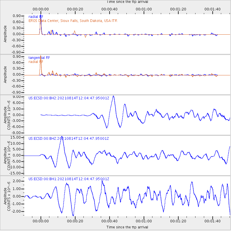
Signal To Noise
| Channel | StoN | STA | LTA |
| US:ECSD:00:BHZ:20210814T12:04:47.95001Z | 12.133051 | 1.4384404E-6 | 1.1855554E-7 |
| US:ECSD:00:BH1:20210814T12:04:47.95001Z | 2.8926656 | 2.410471E-7 | 8.3330434E-8 |
| US:ECSD:00:BH2:20210814T12:04:47.95001Z | 9.015528 | 9.401065E-7 | 1.0427637E-7 |
| Arrivals |
| Ps | 7.0 SECOND |
| PpPs | 22 SECOND |
| PsPs/PpSs | 29 SECOND |


