You are here: Home > Network List > IW - Intermountain West Stations List
> Station MOOW Moose Ponds, Wyoming, USA > Earthquake Result Viewer
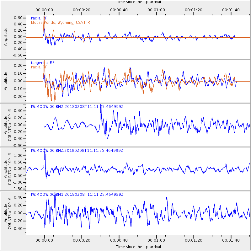
MOOW Moose Ponds, Wyoming, USA - Earthquake Result Viewer
*The percent match for this event was below the threshold and hence no stack was calculated.
| Earthquake location: |
Andreanof Islands, Aleutian Is. |
| Earthquake latitude/longitude: |
52.6/-179.5 |
| Earthquake time(UTC): |
2018/02/08 (039) 11:04:01 GMT |
| Earthquake Depth: |
211 km |
| Earthquake Magnitude: |
5.6 Mww |
| Earthquake Catalog/Contributor: |
NEIC PDE/us |
|
| Network: |
IW Intermountain West |
| Station: |
MOOW Moose Ponds, Wyoming, USA |
| Lat/Lon: |
43.75 N/110.74 W |
| Elevation: |
2128 m |
|
| Distance: |
45.1 deg |
| Az: |
72.557 deg |
| Baz: |
306.529 deg |
| Ray Param: |
$rayparam |
*The percent match for this event was below the threshold and hence was not used in the summary stack. |
|
| Radial Match: |
58.417255 % |
| Radial Bump: |
400 |
| Transverse Match: |
56.071487 % |
| Transverse Bump: |
400 |
| SOD ConfigId: |
2546091 |
| Insert Time: |
2018-02-22 11:08:25.193 +0000 |
| GWidth: |
2.5 |
| Max Bumps: |
400 |
| Tol: |
0.001 |
|
Signal To Noise
| Channel | StoN | STA | LTA |
| IW:MOOW:00:BHZ:20180208T11:11:25.464999Z | 3.124352 | 4.9822125E-7 | 1.5946387E-7 |
| IW:MOOW:00:BH1:20180208T11:11:25.464999Z | 2.4352381 | 1.8230725E-7 | 7.4862186E-8 |
| IW:MOOW:00:BH2:20180208T11:11:25.464999Z | 3.0154414 | 2.5652866E-7 | 8.5071676E-8 |
| Arrivals |
| Ps | |
| PpPs | |
| PsPs/PpSs | |


