You are here: Home > Network List > US - United States National Seismic Network Stations List
> Station SCIA State Center, Iowa, USA > Earthquake Result Viewer
SCIA State Center, Iowa, USA - Earthquake Result Viewer

| Earthquake location: |
Alaska Peninsula |
| Earthquake latitude/longitude: |
55.2/-157.7 |
| Earthquake time(UTC): |
2021/08/14 (226) 11:57:42 GMT |
| Earthquake Depth: |
4.8 km |
| Earthquake Magnitude: |
6.4 ml |
| Earthquake Catalog/Contributor: |
NEIC PDE/ak |
|
| Network: |
US United States National Seismic Network |
| Station: |
SCIA State Center, Iowa, USA |
| Lat/Lon: |
41.91 N/93.22 W |
| Elevation: |
312 m |
|
| Distance: |
43.1 deg |
| Az: |
80.095 deg |
| Baz: |
310.897 deg |
| Ray Param: |
0.072754264 |
| Estimated Moho Depth: |
43.25 km |
| Estimated Crust Vp/Vs: |
1.99 |
| Assumed Crust Vp: |
6.498 km/s |
| Estimated Crust Vs: |
3.269 km/s |
| Estimated Crust Poisson's Ratio: |
0.33 |
|
| Radial Match: |
97.29642 % |
| Radial Bump: |
247 |
| Transverse Match: |
89.08034 % |
| Transverse Bump: |
400 |
| SOD ConfigId: |
25131211 |
| Insert Time: |
2021-08-28 12:24:10.257 +0000 |
| GWidth: |
2.5 |
| Max Bumps: |
400 |
| Tol: |
0.001 |
|
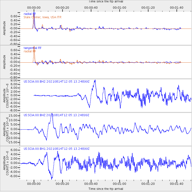
Signal To Noise
| Channel | StoN | STA | LTA |
| US:SCIA:00:BHZ:20210814T12:05:13.24899Z | 12.818129 | 2.0795212E-6 | 1.6223282E-7 |
| US:SCIA:00:BH1:20210814T12:05:13.24899Z | 3.6989853 | 9.2014574E-7 | 2.4875627E-7 |
| US:SCIA:00:BH2:20210814T12:05:13.24899Z | 7.0684733 | 1.0477839E-6 | 1.4823341E-7 |
| Arrivals |
| Ps | 7.0 SECOND |
| PpPs | 19 SECOND |
| PsPs/PpSs | 26 SECOND |


