You are here: Home > Network List > WY - Yellowstone Wyoming Seismic Network Stations List
> Station YTP The Promontory, YNP, WY, USA > Earthquake Result Viewer
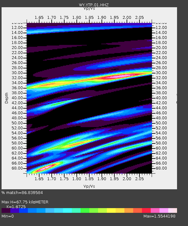
YTP The Promontory, YNP, WY, USA - Earthquake Result Viewer
| Earthquake location: |
Alaska Peninsula |
| Earthquake latitude/longitude: |
55.2/-157.7 |
| Earthquake time(UTC): |
2021/08/14 (226) 11:57:42 GMT |
| Earthquake Depth: |
4.8 km |
| Earthquake Magnitude: |
6.4 ml |
| Earthquake Catalog/Contributor: |
NEIC PDE/ak |
|
| Network: |
WY Yellowstone Wyoming Seismic Network |
| Station: |
YTP The Promontory, YNP, WY, USA |
| Lat/Lon: |
44.39 N/110.29 W |
| Elevation: |
2384 m |
|
| Distance: |
31.9 deg |
| Az: |
89.815 deg |
| Baz: |
306.971 deg |
| Ray Param: |
0.078919515 |
| Estimated Moho Depth: |
67.75 km |
| Estimated Crust Vp/Vs: |
1.67 |
| Assumed Crust Vp: |
6.35 km/s |
| Estimated Crust Vs: |
3.797 km/s |
| Estimated Crust Poisson's Ratio: |
0.22 |
|
| Radial Match: |
86.839584 % |
| Radial Bump: |
387 |
| Transverse Match: |
78.56546 % |
| Transverse Bump: |
400 |
| SOD ConfigId: |
25131211 |
| Insert Time: |
2021-08-28 12:26:12.529 +0000 |
| GWidth: |
2.5 |
| Max Bumps: |
400 |
| Tol: |
0.001 |
|

Signal To Noise
| Channel | StoN | STA | LTA |
| WY:YTP:01:HHZ:20210814T12:03:37.937986Z | 25.746483 | 7.288894E-8 | 2.8310252E-9 |
| WY:YTP:01:HHN:20210814T12:03:37.937986Z | 11.3555765 | 2.6276723E-8 | 2.313993E-9 |
| WY:YTP:01:HHE:20210814T12:03:37.937986Z | 9.320246 | 3.1533137E-8 | 3.3832945E-9 |
| Arrivals |
| Ps | 7.8 SECOND |
| PpPs | 26 SECOND |
| PsPs/PpSs | 34 SECOND |


