You are here: Home > Network List > AV - Alaska Volcano Observatory Stations List
> Station MTBL Table Top, Makushin Volcano, Alaska > Earthquake Result Viewer
MTBL Table Top, Makushin Volcano, Alaska - Earthquake Result Viewer
| Earthquake location: |
Haiti Region |
| Earthquake latitude/longitude: |
18.6/-73.5 |
| Earthquake time(UTC): |
2021/08/14 (226) 12:29:08 GMT |
| Earthquake Depth: |
10 km |
| Earthquake Magnitude: |
7.0 Mi |
| Earthquake Catalog/Contributor: |
NEIC PDE/pt |
|
| Network: |
AV Alaska Volcano Observatory |
| Station: |
MTBL Table Top, Makushin Volcano, Alaska |
| Lat/Lon: |
53.97 N/166.68 W |
| Elevation: |
810 m |
|
| Distance: |
77.0 deg |
| Az: |
322.742 deg |
| Baz: |
76.423 deg |
| Ray Param: |
0.050604876 |
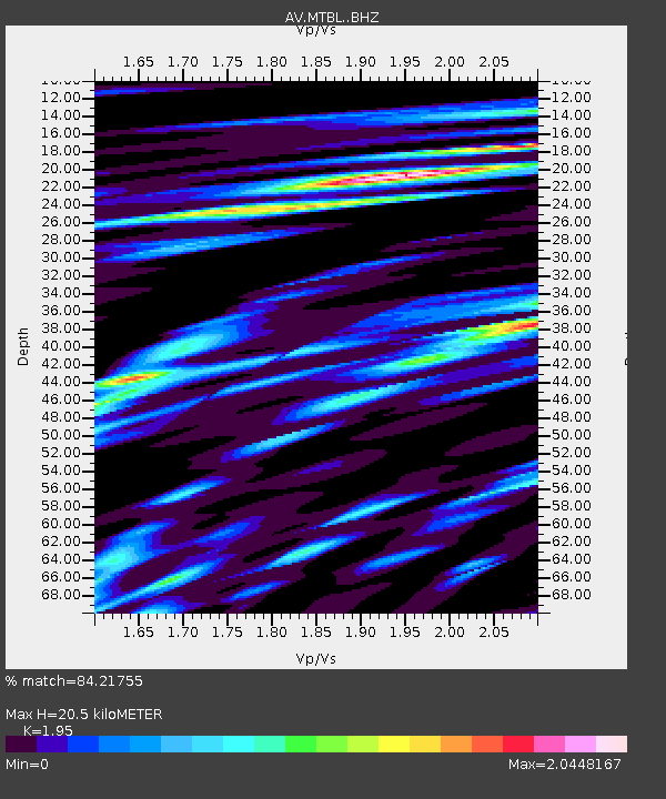
| Estimated Moho Depth: |
20.5 km |
| Estimated Crust Vp/Vs: |
1.95 |
| Assumed Crust Vp: |
3.943 km/s |
| Estimated Crust Vs: |
2.022 km/s |
| Estimated Crust Poisson's Ratio: |
0.32 |
|
| Radial Match: |
84.21755 % |
| Radial Bump: |
400 |
| Transverse Match: |
70.704216 % |
| Transverse Bump: |
359 |
| SOD ConfigId: |
25131211 |
| Insert Time: |
2021-08-28 12:32:01.402 +0000 |
| GWidth: |
2.5 |
| Max Bumps: |
400 |
| Tol: |
0.001 |
|

Signal To Noise
| Channel | StoN | STA | LTA |
| AV:MTBL: :BHZ:20210814T12:40:29.640015Z | 1.7400483 | 8.158014E-6 | 4.6883833E-6 |
| AV:MTBL: :BHN:20210814T12:40:29.640015Z | 0.57204175 | 6.5379277E-6 | 1.1429109E-5 |
| AV:MTBL: :BHE:20210814T12:40:29.640015Z | 2.3584259 | 1.42088675E-5 | 6.024725E-6 |
| Arrivals |
| Ps | 5.0 SECOND |
| PpPs | 15 SECOND |
| PsPs/PpSs | 20 SECOND |


