You are here: Home > Network List > BL - Brazilian Lithospheric Seismic Project (BLSP) Stations List
> Station PMNB Patos de Minas, MG > Earthquake Result Viewer
PMNB Patos de Minas, MG - Earthquake Result Viewer
| Earthquake location: |
Haiti Region |
| Earthquake latitude/longitude: |
18.6/-73.5 |
| Earthquake time(UTC): |
2021/08/14 (226) 12:29:08 GMT |
| Earthquake Depth: |
10 km |
| Earthquake Magnitude: |
7.0 Mi |
| Earthquake Catalog/Contributor: |
NEIC PDE/pt |
|
| Network: |
BL Brazilian Lithospheric Seismic Project (BLSP) |
| Station: |
PMNB Patos de Minas, MG |
| Lat/Lon: |
18.54 S/46.44 W |
| Elevation: |
950 m |
|
| Distance: |
45.5 deg |
| Az: |
142.677 deg |
| Baz: |
322.682 deg |
| Ray Param: |
0.07125702 |
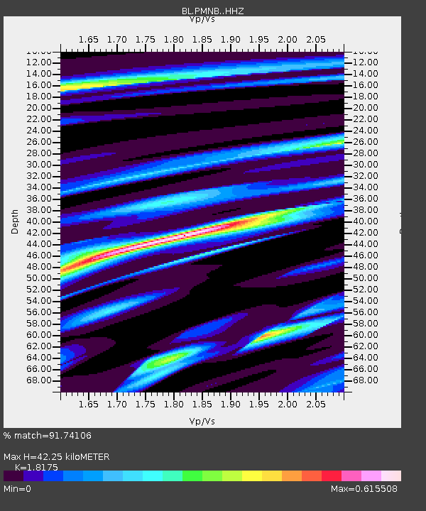
| Estimated Moho Depth: |
42.25 km |
| Estimated Crust Vp/Vs: |
1.82 |
| Assumed Crust Vp: |
6.419 km/s |
| Estimated Crust Vs: |
3.532 km/s |
| Estimated Crust Poisson's Ratio: |
0.28 |
|
| Radial Match: |
91.74106 % |
| Radial Bump: |
258 |
| Transverse Match: |
53.75898 % |
| Transverse Bump: |
400 |
| SOD ConfigId: |
25131211 |
| Insert Time: |
2021-08-28 12:33:06.463 +0000 |
| GWidth: |
2.5 |
| Max Bumps: |
400 |
| Tol: |
0.001 |
|

Signal To Noise
| Channel | StoN | STA | LTA |
| BL:PMNB: :HHZ:20210814T12:36:56.359985Z | 13.173699 | 1.194405E-5 | 9.066588E-7 |
| BL:PMNB: :HHN:20210814T12:36:56.359985Z | 4.4658003 | 6.5004015E-6 | 1.455596E-6 |
| BL:PMNB: :HHE:20210814T12:36:56.359985Z | 1.44586 | 2.758701E-6 | 1.908E-6 |
| Arrivals |
| Ps | 5.7 SECOND |
| PpPs | 17 SECOND |
| PsPs/PpSs | 23 SECOND |


