You are here: Home > Network List > CC - Cascade Chain Volcano Monitoring Stations List
> Station LSON Lamberson Butte > Earthquake Result Viewer
LSON Lamberson Butte - Earthquake Result Viewer
| Earthquake location: |
Haiti Region |
| Earthquake latitude/longitude: |
18.6/-73.5 |
| Earthquake time(UTC): |
2021/08/14 (226) 12:29:08 GMT |
| Earthquake Depth: |
10 km |
| Earthquake Magnitude: |
7.0 Mi |
| Earthquake Catalog/Contributor: |
NEIC PDE/pt |
|
| Network: |
CC Cascade Chain Volcano Monitoring |
| Station: |
LSON Lamberson Butte |
| Lat/Lon: |
45.36 N/121.65 W |
| Elevation: |
1881 m |
|
| Distance: |
47.9 deg |
| Az: |
314.946 deg |
| Baz: |
107.765 deg |
| Ray Param: |
0.06974486 |
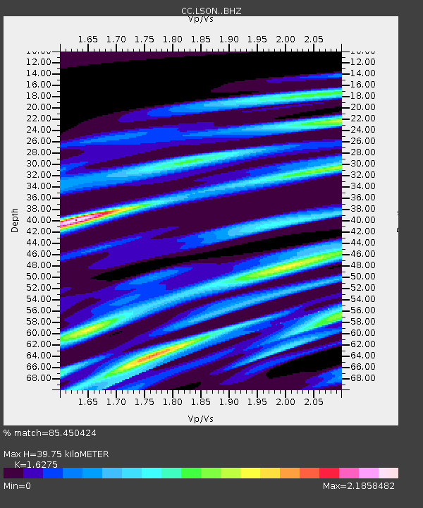
| Estimated Moho Depth: |
39.75 km |
| Estimated Crust Vp/Vs: |
1.63 |
| Assumed Crust Vp: |
6.597 km/s |
| Estimated Crust Vs: |
4.054 km/s |
| Estimated Crust Poisson's Ratio: |
0.20 |
|
| Radial Match: |
85.450424 % |
| Radial Bump: |
400 |
| Transverse Match: |
74.20747 % |
| Transverse Bump: |
400 |
| SOD ConfigId: |
25131211 |
| Insert Time: |
2021-08-28 12:35:01.963 +0000 |
| GWidth: |
2.5 |
| Max Bumps: |
400 |
| Tol: |
0.001 |
|

Signal To Noise
| Channel | StoN | STA | LTA |
| CC:LSON: :BHZ:20210814T12:37:14.940002Z | 2.3881814 | 1.0072713E-5 | 4.2177335E-6 |
| CC:LSON: :BHN:20210814T12:37:14.940002Z | 0.5403927 | 2.2222E-6 | 4.112195E-6 |
| CC:LSON: :BHE:20210814T12:37:14.940002Z | 1.8434484 | 1.3351121E-5 | 7.242471E-6 |
| Arrivals |
| Ps | 4.1 SECOND |
| PpPs | 15 SECOND |
| PsPs/PpSs | 19 SECOND |


