You are here: Home > Network List > NM - Cooperative New Madrid Seismic Network Stations List
> Station UTMT Martin, TN > Earthquake Result Viewer
UTMT Martin, TN - Earthquake Result Viewer
| Earthquake location: |
Northern Peru |
| Earthquake latitude/longitude: |
-7.3/-77.9 |
| Earthquake time(UTC): |
2005/04/11 (101) 14:54:07 GMT |
| Earthquake Depth: |
130 km |
| Earthquake Magnitude: |
6.1 MB, 6.0 MW, 5.9 MW |
| Earthquake Catalog/Contributor: |
WHDF/NEIC |
|
| Network: |
NM Cooperative New Madrid Seismic Network |
| Station: |
UTMT Martin, TN |
| Lat/Lon: |
36.34 N/88.86 W |
| Elevation: |
120 m |
|
| Distance: |
44.6 deg |
| Az: |
347.354 deg |
| Baz: |
164.396 deg |
| Ray Param: |
0.071340874 |
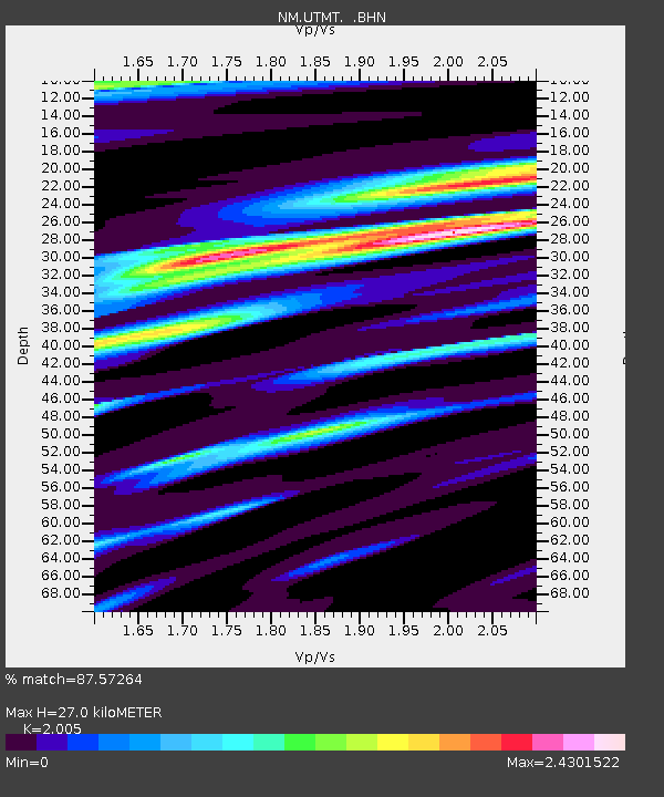
| Estimated Moho Depth: |
27.0 km |
| Estimated Crust Vp/Vs: |
2.01 |
| Assumed Crust Vp: |
6.444 km/s |
| Estimated Crust Vs: |
3.214 km/s |
| Estimated Crust Poisson's Ratio: |
0.33 |
|
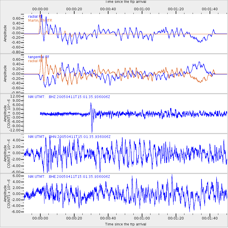
| Radial Match: |
87.57264 % |
| Radial Bump: |
400 |
| Transverse Match: |
70.080505 % |
| Transverse Bump: |
400 |
| SOD ConfigId: |
2459 |
| Insert Time: |
2010-03-09 11:41:50.897 +0000 |
| GWidth: |
2.5 |
| Max Bumps: |
400 |
| Tol: |
0.001 |
|
Signal To Noise
| Channel | StoN | STA | LTA |
| NM:UTMT: :BHN:20050411T15:01:35.936006Z | 3.4464848 | 2.6110774E-6 | 7.57606E-7 |
| NM:UTMT: :BHE:20050411T15:01:35.936006Z | 1.2386272 | 1.399128E-6 | 1.1295797E-6 |
| NM:UTMT: :BHZ:20050411T15:01:35.936006Z | 6.5544047 | 3.9813176E-6 | 6.0742633E-7 |
| Arrivals |
| Ps | 4.5 SECOND |
| PpPs | 12 SECOND |
| PsPs/PpSs | 16 SECOND |


