You are here: Home > Network List > NM - Cooperative New Madrid Seismic Network Stations List
> Station UTMT Martin, TN > Earthquake Result Viewer
UTMT Martin, TN - Earthquake Result Viewer
| Earthquake location: |
East Of Kuril Islands |
| Earthquake latitude/longitude: |
46.8/154.1 |
| Earthquake time(UTC): |
2005/10/15 (288) 10:06:17 GMT |
| Earthquake Depth: |
43 km |
| Earthquake Magnitude: |
6.0 MB, 5.7 MS, 6.1 MW, 6.0 MW |
| Earthquake Catalog/Contributor: |
WHDF/NEIC |
|
| Network: |
NM Cooperative New Madrid Seismic Network |
| Station: |
UTMT Martin, TN |
| Lat/Lon: |
36.34 N/88.86 W |
| Elevation: |
120 m |
|
| Distance: |
79.8 deg |
| Az: |
46.951 deg |
| Baz: |
321.566 deg |
| Ray Param: |
0.048636783 |
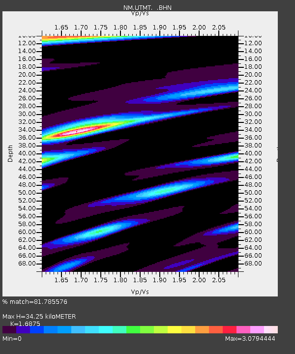
| Estimated Moho Depth: |
34.25 km |
| Estimated Crust Vp/Vs: |
1.69 |
| Assumed Crust Vp: |
6.444 km/s |
| Estimated Crust Vs: |
3.819 km/s |
| Estimated Crust Poisson's Ratio: |
0.23 |
|
| Radial Match: |
81.785576 % |
| Radial Bump: |
400 |
| Transverse Match: |
60.406445 % |
| Transverse Bump: |
400 |
| SOD ConfigId: |
2422 |
| Insert Time: |
2010-03-09 11:41:53.098 +0000 |
| GWidth: |
2.5 |
| Max Bumps: |
400 |
| Tol: |
0.001 |
|
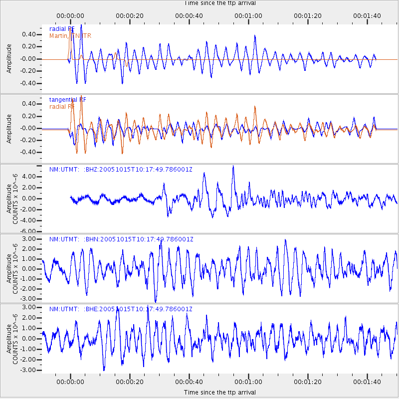
Signal To Noise
| Channel | StoN | STA | LTA |
| NM:UTMT: :BHN:20051015T10:17:49.786001Z | 1.3590273 | 1.2096806E-6 | 8.901077E-7 |
| NM:UTMT: :BHE:20051015T10:17:49.786001Z | 1.2569748 | 8.441123E-7 | 6.7154275E-7 |
| NM:UTMT: :BHZ:20051015T10:17:49.786001Z | 3.4140635 | 1.5216048E-6 | 4.4568733E-7 |
| Arrivals |
| Ps | 3.8 SECOND |
| PpPs | 14 SECOND |
| PsPs/PpSs | 18 SECOND |


