You are here: Home > Network List > NM - Cooperative New Madrid Seismic Network Stations List
> Station UTMT Martin, TN > Earthquake Result Viewer
UTMT Martin, TN - Earthquake Result Viewer
| Earthquake location: |
Near Coast Of Peru |
| Earthquake latitude/longitude: |
-17.8/-70.1 |
| Earthquake time(UTC): |
2005/07/13 (194) 12:06:13 GMT |
| Earthquake Depth: |
80 km |
| Earthquake Magnitude: |
5.6 MB, 5.9 MW, 5.8 MW |
| Earthquake Catalog/Contributor: |
WHDF/NEIC |
|
| Network: |
NM Cooperative New Madrid Seismic Network |
| Station: |
UTMT Martin, TN |
| Lat/Lon: |
36.34 N/88.86 W |
| Elevation: |
120 m |
|
| Distance: |
56.7 deg |
| Az: |
341.914 deg |
| Baz: |
158.516 deg |
| Ray Param: |
0.06371857 |
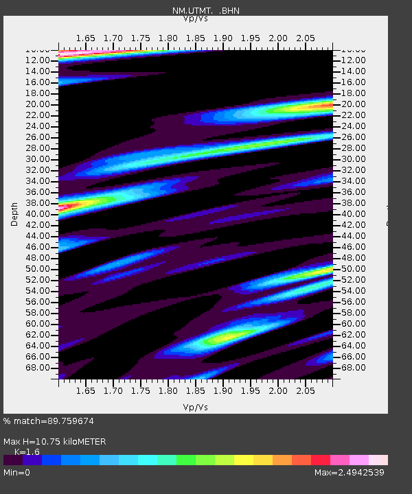
| Estimated Moho Depth: |
10.75 km |
| Estimated Crust Vp/Vs: |
1.60 |
| Assumed Crust Vp: |
6.444 km/s |
| Estimated Crust Vs: |
4.027 km/s |
| Estimated Crust Poisson's Ratio: |
0.18 |
|
| Radial Match: |
89.759674 % |
| Radial Bump: |
400 |
| Transverse Match: |
82.86146 % |
| Transverse Bump: |
400 |
| SOD ConfigId: |
2500 |
| Insert Time: |
2010-03-09 11:41:56.723 +0000 |
| GWidth: |
2.5 |
| Max Bumps: |
400 |
| Tol: |
0.001 |
|
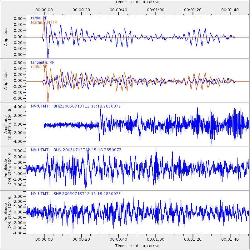
Signal To Noise
| Channel | StoN | STA | LTA |
| NM:UTMT: :BHN:20050713T12:15:18.285007Z | 3.1237755 | 1.1223916E-6 | 3.593061E-7 |
| NM:UTMT: :BHE:20050713T12:15:18.285007Z | 2.0612993 | 8.967327E-7 | 4.3503272E-7 |
| NM:UTMT: :BHZ:20050713T12:15:18.285007Z | 4.6281524 | 1.5205318E-6 | 3.2853967E-7 |
| Arrivals |
| Ps | 1.1 SECOND |
| PpPs | 4.1 SECOND |
| PsPs/PpSs | 5.2 SECOND |


