You are here: Home > Network List > NM - Cooperative New Madrid Seismic Network Stations List
> Station UTMT Martin, TN > Earthquake Result Viewer
UTMT Martin, TN - Earthquake Result Viewer
| Earthquake location: |
Near West Coast Of Colombia |
| Earthquake latitude/longitude: |
3.0/-78.0 |
| Earthquake time(UTC): |
2007/09/10 (253) 01:49:14 GMT |
| Earthquake Depth: |
31 km |
| Earthquake Magnitude: |
6.1 MB, 6.7 MS, 6.8 MW |
| Earthquake Catalog/Contributor: |
WHDF/NEIC |
|
| Network: |
NM Cooperative New Madrid Seismic Network |
| Station: |
UTMT Martin, TN |
| Lat/Lon: |
36.34 N/88.86 W |
| Elevation: |
120 m |
|
| Distance: |
34.7 deg |
| Az: |
344.443 deg |
| Baz: |
160.626 deg |
| Ray Param: |
0.07755838 |
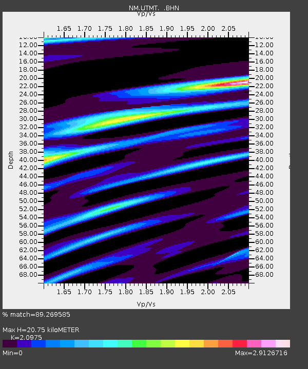
| Estimated Moho Depth: |
20.75 km |
| Estimated Crust Vp/Vs: |
2.10 |
| Assumed Crust Vp: |
6.444 km/s |
| Estimated Crust Vs: |
3.072 km/s |
| Estimated Crust Poisson's Ratio: |
0.35 |
|
| Radial Match: |
89.269585 % |
| Radial Bump: |
400 |
| Transverse Match: |
51.868973 % |
| Transverse Bump: |
400 |
| SOD ConfigId: |
2564 |
| Insert Time: |
2010-03-09 11:42:00.052 +0000 |
| GWidth: |
2.5 |
| Max Bumps: |
400 |
| Tol: |
0.001 |
|

Signal To Noise
| Channel | StoN | STA | LTA |
| NM:UTMT: :BHN:20070910T01:55:30.673003Z | 2.1575737 | 2.0312661E-6 | 9.4145855E-7 |
| NM:UTMT: :BHE:20070910T01:55:30.673003Z | 0.9311202 | 7.368585E-7 | 7.9136777E-7 |
| NM:UTMT: :BHZ:20070910T01:55:30.673003Z | 3.2775226 | 2.137893E-6 | 6.522894E-7 |
| Arrivals |
| Ps | 3.8 SECOND |
| PpPs | 9.3 SECOND |
| PsPs/PpSs | 13 SECOND |


