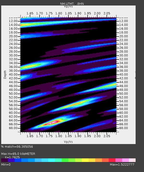
UTMT Martin, TN - Earthquake Result Viewer
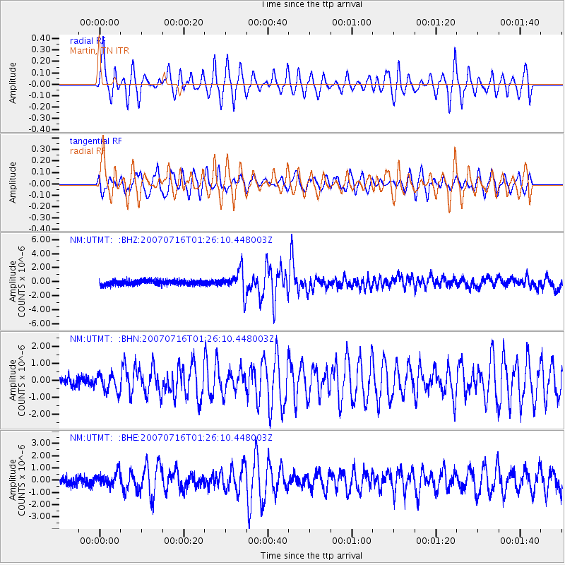
Earthquake location: Near West Coast Of Honshu, Japan
Earthquake latitude/longitude: 37.5/138.4
Earthquake time(UTC): 2007/07/16 (197) 01:13:22 GMT
Earthquake Depth: 12 km
Earthquake Magnitude: 6.5 MB, 6.4 MS, 6.6 MW, 6.5 MW
Earthquake Catalog/Contributor: WHDF/NEIC
Network: NM Cooperative New Madrid Seismic Network
Station: UTMT Martin, TN
Lat/Lon: 36.34 N/88.86 W
Elevation: 120 m
Distance: 94.4 deg
Az: 36.529 deg
Baz: 324.121 deg
Ray Param: 0.04104449
Estimated Moho Depth: 65.0 km
Estimated Crust Vp/Vs: 1.76
Assumed Crust Vp: 6.444 km/s
Estimated Crust Vs: 3.656 km/s
Estimated Crust Poisson's Ratio: 0.26
Radial Match: 86.385056 %
Radial Bump: 400
Transverse Match: 81.01208 %
Transverse Bump: 400
SOD ConfigId: 2564
Insert Time: 2010-03-09 11:42:04.579 +0000
GWidth: 2.5
Max Bumps: 400
Tol: 0.001

Signal To Noise

ChannelStoNSTALTA
NM:UTMT: :BHN:20070716T01:26:10.448003Z1.71365385.230141E-73.0520408E-7
NM:UTMT: :BHE:20070716T01:26:10.448003Z1.32342745.292649E-73.9991986E-7
NM:UTMT: :BHZ:20070716T01:26:10.448003Z4.78216361.7232757E-63.603548E-7
Arrivals
Ps7.8 SECOND
PpPs27 SECOND
PsPs/PpSs35 SECOND