You are here: Home > Network List > AK - Alaska Regional Network Stations List
> Station E27K Coleen River, AK, USA > Earthquake Result Viewer
E27K Coleen River, AK, USA - Earthquake Result Viewer
| Earthquake location: |
Haiti Region |
| Earthquake latitude/longitude: |
18.4/-74.1 |
| Earthquake time(UTC): |
2021/08/15 (227) 03:20:45 GMT |
| Earthquake Depth: |
12 km |
| Earthquake Magnitude: |
5.8 mww |
| Earthquake Catalog/Contributor: |
NEIC PDE/us |
|
| Network: |
AK Alaska Regional Network |
| Station: |
E27K Coleen River, AK, USA |
| Lat/Lon: |
68.19 N/141.60 W |
| Elevation: |
654 m |
|
| Distance: |
64.8 deg |
| Az: |
337.559 deg |
| Baz: |
104.081 deg |
| Ray Param: |
0.058713548 |
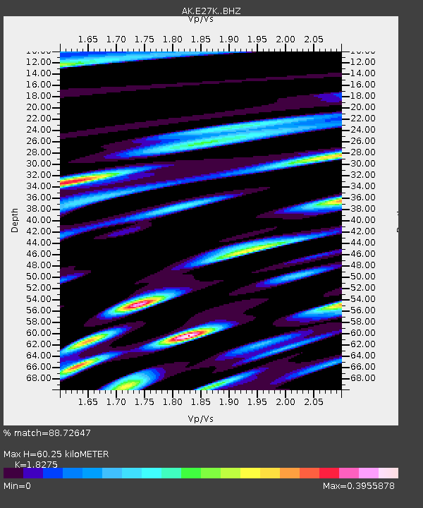
| Estimated Moho Depth: |
60.25 km |
| Estimated Crust Vp/Vs: |
1.83 |
| Assumed Crust Vp: |
6.522 km/s |
| Estimated Crust Vs: |
3.569 km/s |
| Estimated Crust Poisson's Ratio: |
0.29 |
|
| Radial Match: |
88.72647 % |
| Radial Bump: |
329 |
| Transverse Match: |
84.71107 % |
| Transverse Bump: |
379 |
| SOD ConfigId: |
25131211 |
| Insert Time: |
2021-08-29 03:22:52.147 +0000 |
| GWidth: |
2.5 |
| Max Bumps: |
400 |
| Tol: |
0.001 |
|

Signal To Noise
| Channel | StoN | STA | LTA |
| AK:E27K: :BHZ:20210815T03:30:52.679981Z | 18.170685 | 1.3629784E-6 | 7.5009744E-8 |
| AK:E27K: :BHN:20210815T03:30:52.679981Z | 1.626253 | 9.784434E-8 | 6.0165505E-8 |
| AK:E27K: :BHE:20210815T03:30:52.679981Z | 8.238132 | 4.6374228E-7 | 5.6292162E-8 |
| Arrivals |
| Ps | 8.0 SECOND |
| PpPs | 25 SECOND |
| PsPs/PpSs | 33 SECOND |


