You are here: Home > Network List > NM - Cooperative New Madrid Seismic Network Stations List
> Station UTMT Martin, TN > Earthquake Result Viewer
UTMT Martin, TN - Earthquake Result Viewer
| Earthquake location: |
Colombia |
| Earthquake latitude/longitude: |
4.5/-75.7 |
| Earthquake time(UTC): |
1999/01/25 (025) 18:19:16 GMT |
| Earthquake Depth: |
17 km |
| Earthquake Magnitude: |
5.9 MB, 5.7 MS, 6.3 ME, 6.2 MW |
| Earthquake Catalog/Contributor: |
WHDF/NEIC |
|
| Network: |
NM Cooperative New Madrid Seismic Network |
| Station: |
UTMT Martin, TN |
| Lat/Lon: |
36.34 N/88.86 W |
| Elevation: |
120 m |
|
| Distance: |
34.0 deg |
| Az: |
340.815 deg |
| Baz: |
156.059 deg |
| Ray Param: |
0.07795498 |
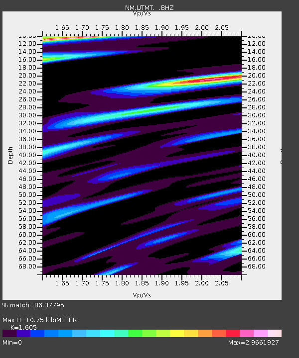
| Estimated Moho Depth: |
10.75 km |
| Estimated Crust Vp/Vs: |
1.61 |
| Assumed Crust Vp: |
6.444 km/s |
| Estimated Crust Vs: |
4.015 km/s |
| Estimated Crust Poisson's Ratio: |
0.18 |
|
| Radial Match: |
86.37795 % |
| Radial Bump: |
400 |
| Transverse Match: |
75.55508 % |
| Transverse Bump: |
400 |
| SOD ConfigId: |
4480 |
| Insert Time: |
2010-03-09 11:42:10.124 +0000 |
| GWidth: |
2.5 |
| Max Bumps: |
400 |
| Tol: |
0.001 |
|
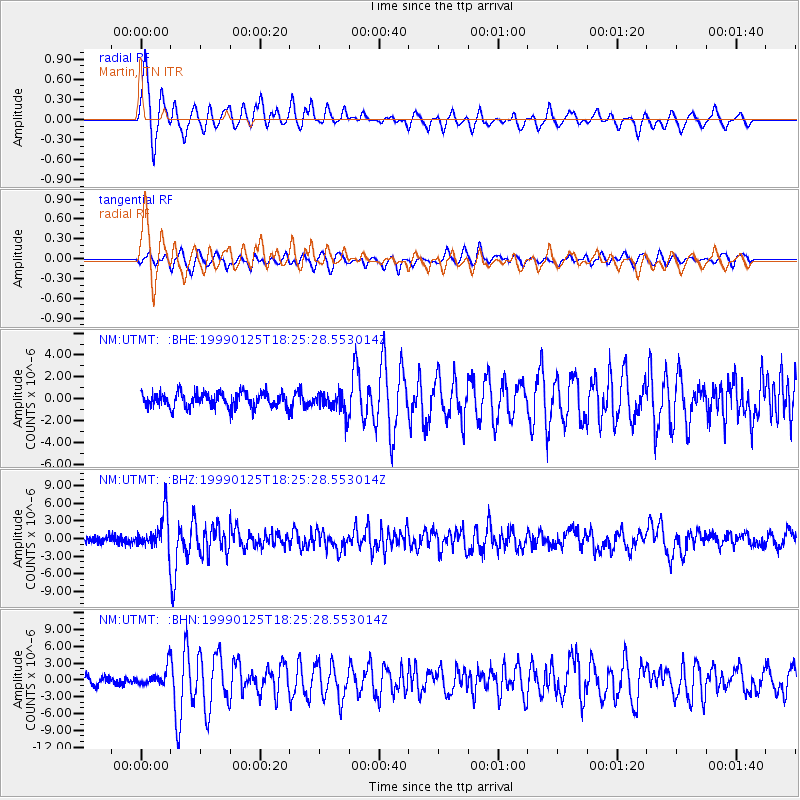
Signal To Noise
| Channel | StoN | STA | LTA |
| NM:UTMT: :BHZ:19990125T18:25:28.553014Z | 5.6070905 | 3.0729523E-6 | 5.480476E-7 |
| NM:UTMT: :BHN:19990125T18:25:28.553014Z | 1.7977473 | 1.7138592E-6 | 9.533371E-7 |
| NM:UTMT: :BHE:19990125T18:25:28.553014Z | 1.4792486 | 1.0062946E-6 | 6.802742E-7 |
| Arrivals |
| Ps | 1.1 SECOND |
| PpPs | 4.0 SECOND |
| PsPs/PpSs | 5.1 SECOND |


