You are here: Home > Network List > AK - Alaska Regional Network Stations List
> Station J17K VABM Dome, AK, USA > Earthquake Result Viewer
J17K VABM Dome, AK, USA - Earthquake Result Viewer
| Earthquake location: |
Haiti Region |
| Earthquake latitude/longitude: |
18.4/-74.1 |
| Earthquake time(UTC): |
2021/08/15 (227) 03:20:45 GMT |
| Earthquake Depth: |
12 km |
| Earthquake Magnitude: |
5.8 mww |
| Earthquake Catalog/Contributor: |
NEIC PDE/us |
|
| Network: |
AK Alaska Regional Network |
| Station: |
J17K VABM Dome, AK, USA |
| Lat/Lon: |
63.40 N/159.08 W |
| Elevation: |
323 m |
|
| Distance: |
71.5 deg |
| Az: |
331.777 deg |
| Baz: |
85.96 deg |
| Ray Param: |
0.054286525 |
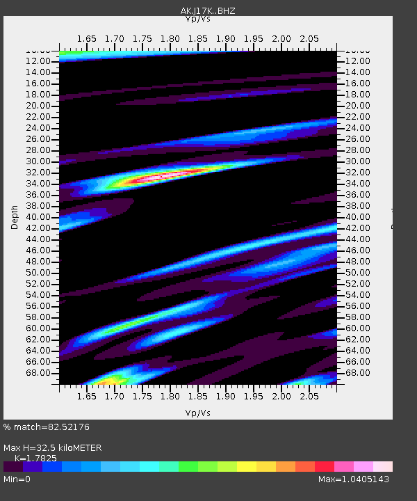
| Estimated Moho Depth: |
32.5 km |
| Estimated Crust Vp/Vs: |
1.78 |
| Assumed Crust Vp: |
6.276 km/s |
| Estimated Crust Vs: |
3.521 km/s |
| Estimated Crust Poisson's Ratio: |
0.27 |
|
| Radial Match: |
82.52176 % |
| Radial Bump: |
400 |
| Transverse Match: |
64.341545 % |
| Transverse Bump: |
400 |
| SOD ConfigId: |
25131211 |
| Insert Time: |
2021-08-29 03:23:44.138 +0000 |
| GWidth: |
2.5 |
| Max Bumps: |
400 |
| Tol: |
0.001 |
|

Signal To Noise
| Channel | StoN | STA | LTA |
| AK:J17K: :BHZ:20210815T03:31:34.939991Z | 7.914579 | 6.522697E-7 | 8.24137E-8 |
| AK:J17K: :BHN:20210815T03:31:34.939991Z | 0.7578951 | 7.3927445E-8 | 9.754311E-8 |
| AK:J17K: :BHE:20210815T03:31:34.939991Z | 4.045049 | 3.0850583E-7 | 7.626751E-8 |
| Arrivals |
| Ps | 4.2 SECOND |
| PpPs | 14 SECOND |
| PsPs/PpSs | 18 SECOND |


