You are here: Home > Network List > NM - Cooperative New Madrid Seismic Network Stations List
> Station UTMT Martin, TN > Earthquake Result Viewer
UTMT Martin, TN - Earthquake Result Viewer

| Earthquake location: |
Southern Peru |
| Earthquake latitude/longitude: |
-15.0/-70.4 |
| Earthquake time(UTC): |
2009/07/12 (193) 06:12:47 GMT |
| Earthquake Depth: |
199 km |
| Earthquake Magnitude: |
5.7 MB, 6.1 MW, 6.1 MW |
| Earthquake Catalog/Contributor: |
WHDF/NEIC |
|
| Network: |
NM Cooperative New Madrid Seismic Network |
| Station: |
UTMT Martin, TN |
| Lat/Lon: |
36.34 N/88.86 W |
| Elevation: |
120 m |
|
| Distance: |
54.0 deg |
| Az: |
341.616 deg |
| Baz: |
157.827 deg |
| Ray Param: |
0.06505425 |
| Estimated Moho Depth: |
10.5 km |
| Estimated Crust Vp/Vs: |
1.61 |
| Assumed Crust Vp: |
6.444 km/s |
| Estimated Crust Vs: |
4.015 km/s |
| Estimated Crust Poisson's Ratio: |
0.18 |
|
| Radial Match: |
84.70167 % |
| Radial Bump: |
400 |
| Transverse Match: |
84.71475 % |
| Transverse Bump: |
400 |
| SOD ConfigId: |
2648 |
| Insert Time: |
2010-03-09 11:42:11.515 +0000 |
| GWidth: |
2.5 |
| Max Bumps: |
400 |
| Tol: |
0.001 |
|
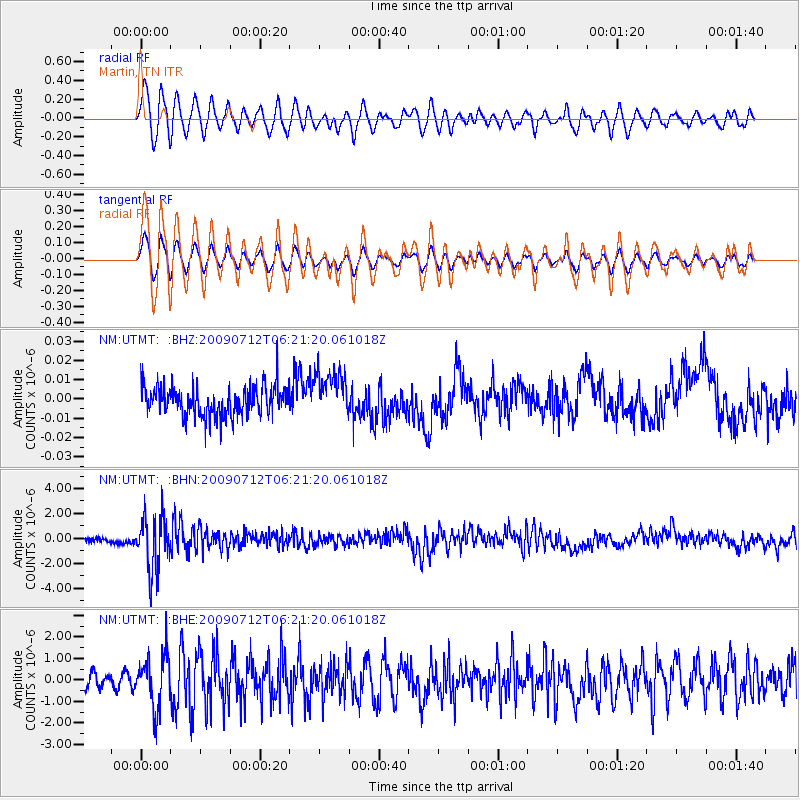
Signal To Noise
| Channel | StoN | STA | LTA |
| NM:UTMT: :BHN:20090712T06:21:20.061018Z | 10.446931 | 2.2088159E-6 | 2.1143205E-7 |
| NM:UTMT: :BHE:20090712T06:21:20.061018Z | 4.747317 | 1.2308323E-6 | 2.5926903E-7 |
| NM:UTMT: :BHZ:20090712T06:21:20.061018Z | 1.5853719 | 1.2189169E-8 | 7.688524E-9 |
| Arrivals |
| Ps | 1.0 SECOND |
| PpPs | 4.0 SECOND |
| PsPs/PpSs | 5.0 SECOND |


