You are here: Home > Network List > NM - Cooperative New Madrid Seismic Network Stations List
> Station UTMT Martin, TN > Earthquake Result Viewer
UTMT Martin, TN - Earthquake Result Viewer
| Earthquake location: |
Kuril Islands |
| Earthquake latitude/longitude: |
46.6/153.3 |
| Earthquake time(UTC): |
2006/11/15 (319) 11:14:13 GMT |
| Earthquake Depth: |
10 km |
| Earthquake Magnitude: |
6.5 MB, 7.8 MS, 8.3 MW, 7.9 MW |
| Earthquake Catalog/Contributor: |
WHDF/NEIC |
|
| Network: |
NM Cooperative New Madrid Seismic Network |
| Station: |
UTMT Martin, TN |
| Lat/Lon: |
36.34 N/88.86 W |
| Elevation: |
120 m |
|
| Distance: |
80.4 deg |
| Az: |
46.378 deg |
| Baz: |
321.807 deg |
| Ray Param: |
0.04831152 |
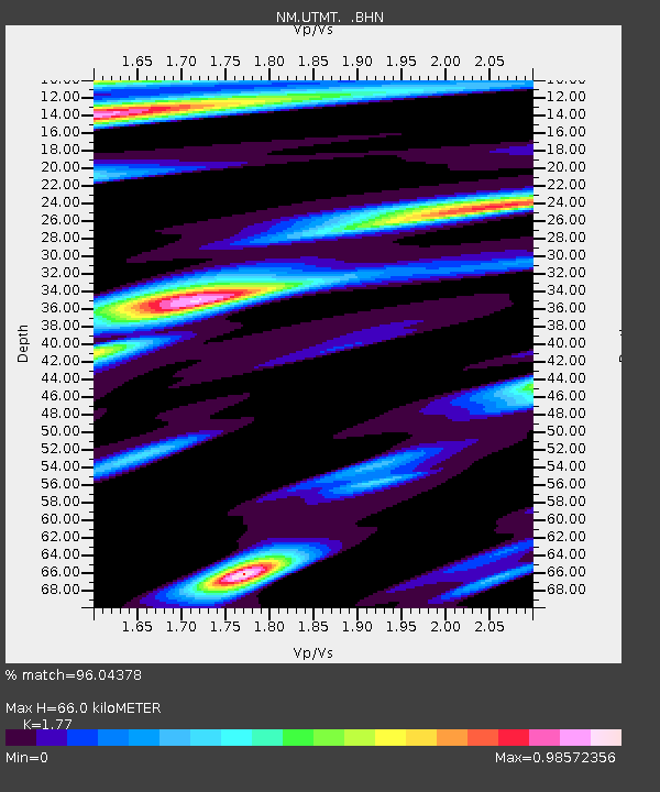
| Estimated Moho Depth: |
66.0 km |
| Estimated Crust Vp/Vs: |
1.77 |
| Assumed Crust Vp: |
6.444 km/s |
| Estimated Crust Vs: |
3.641 km/s |
| Estimated Crust Poisson's Ratio: |
0.27 |
|
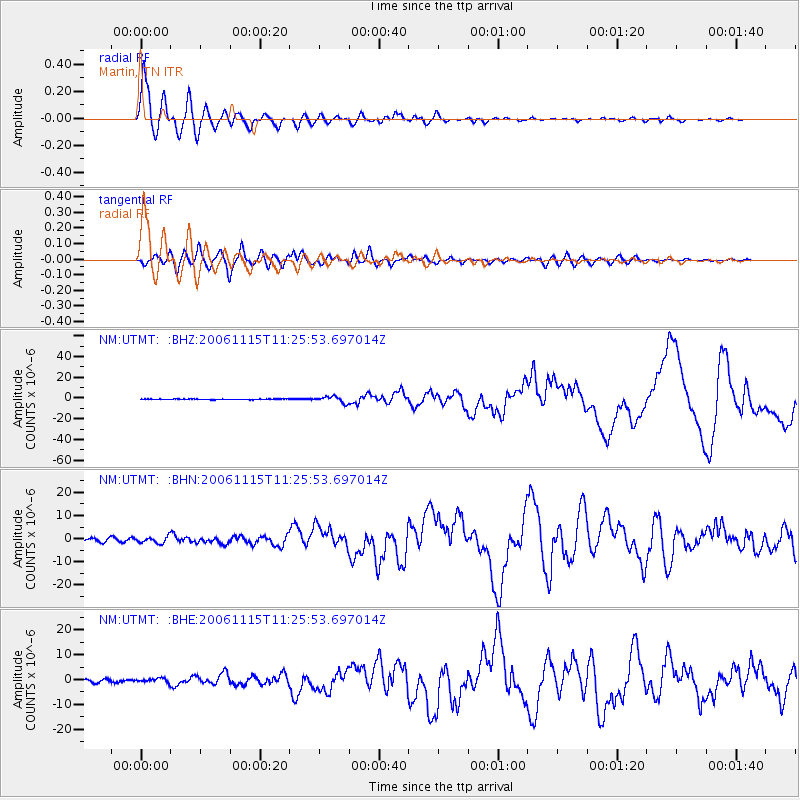
| Radial Match: |
96.04378 % |
| Radial Bump: |
400 |
| Transverse Match: |
83.30383 % |
| Transverse Bump: |
400 |
| SOD ConfigId: |
2564 |
| Insert Time: |
2010-03-09 11:42:14.033 +0000 |
| GWidth: |
2.5 |
| Max Bumps: |
400 |
| Tol: |
0.001 |
|
Signal To Noise
| Channel | StoN | STA | LTA |
| NM:UTMT: :BHN:20061115T11:25:53.697014Z | 1.7002484 | 1.4616638E-6 | 8.596767E-7 |
| NM:UTMT: :BHE:20061115T11:25:53.697014Z | 1.4655067 | 8.3887187E-7 | 5.7241084E-7 |
| NM:UTMT: :BHZ:20061115T11:25:53.697014Z | 9.44228 | 2.9439914E-6 | 3.117882E-7 |
| Arrivals |
| Ps | 8.1 SECOND |
| PpPs | 28 SECOND |
| PsPs/PpSs | 36 SECOND |


