You are here: Home > Network List > NM - Cooperative New Madrid Seismic Network Stations List
> Station UTMT Martin, TN > Earthquake Result Viewer
UTMT Martin, TN - Earthquake Result Viewer
| Earthquake location: |
Chile-Argentina Border Region |
| Earthquake latitude/longitude: |
-24.4/-67.0 |
| Earthquake time(UTC): |
2006/08/25 (237) 00:44:46 GMT |
| Earthquake Depth: |
184 km |
| Earthquake Magnitude: |
5.9 MB, 6.6 MW, 6.6 MW |
| Earthquake Catalog/Contributor: |
WHDF/NEIC |
|
| Network: |
NM Cooperative New Madrid Seismic Network |
| Station: |
UTMT Martin, TN |
| Lat/Lon: |
36.34 N/88.86 W |
| Elevation: |
120 m |
|
| Distance: |
63.8 deg |
| Az: |
340.453 deg |
| Baz: |
157.803 deg |
| Ray Param: |
0.058762774 |
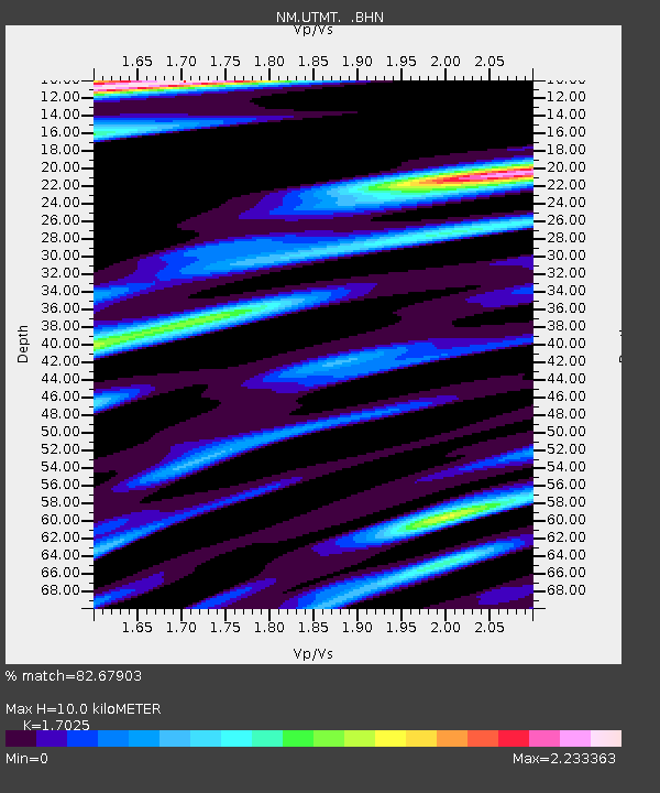
| Estimated Moho Depth: |
10.0 km |
| Estimated Crust Vp/Vs: |
1.70 |
| Assumed Crust Vp: |
6.444 km/s |
| Estimated Crust Vs: |
3.785 km/s |
| Estimated Crust Poisson's Ratio: |
0.24 |
|
| Radial Match: |
82.67903 % |
| Radial Bump: |
400 |
| Transverse Match: |
70.756065 % |
| Transverse Bump: |
400 |
| SOD ConfigId: |
2564 |
| Insert Time: |
2010-03-09 11:42:20.673 +0000 |
| GWidth: |
2.5 |
| Max Bumps: |
400 |
| Tol: |
0.001 |
|
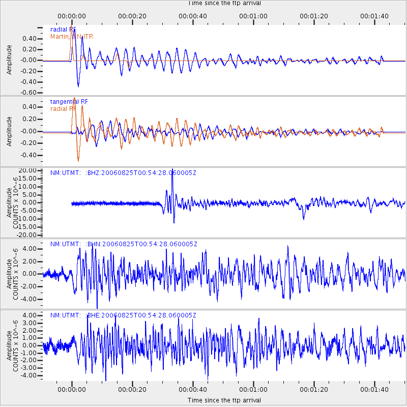
Signal To Noise
| Channel | StoN | STA | LTA |
| NM:UTMT: :BHN:20060825T00:54:28.060005Z | 4.4548903 | 2.038817E-6 | 4.576582E-7 |
| NM:UTMT: :BHE:20060825T00:54:28.060005Z | 2.7153711 | 1.2747122E-6 | 4.6944308E-7 |
| NM:UTMT: :BHZ:20060825T00:54:28.060005Z | 14.634238 | 6.6984167E-6 | 4.5772225E-7 |
| Arrivals |
| Ps | 1.1 SECOND |
| PpPs | 4.0 SECOND |
| PsPs/PpSs | 5.2 SECOND |


