You are here: Home > Network List > NM - Cooperative New Madrid Seismic Network Stations List
> Station UTMT Martin, TN > Earthquake Result Viewer
UTMT Martin, TN - Earthquake Result Viewer
| Earthquake location: |
South Of Panama |
| Earthquake latitude/longitude: |
6.0/-82.7 |
| Earthquake time(UTC): |
2000/12/12 (347) 05:26:45 GMT |
| Earthquake Depth: |
10 km |
| Earthquake Magnitude: |
5.8 MB, 5.7 MS, 6.3 ME, 6.1 MW |
| Earthquake Catalog/Contributor: |
WHDF/NEIC |
|
| Network: |
NM Cooperative New Madrid Seismic Network |
| Station: |
UTMT Martin, TN |
| Lat/Lon: |
36.34 N/88.86 W |
| Elevation: |
120 m |
|
| Distance: |
30.7 deg |
| Az: |
350.193 deg |
| Baz: |
167.889 deg |
| Ray Param: |
0.079260014 |
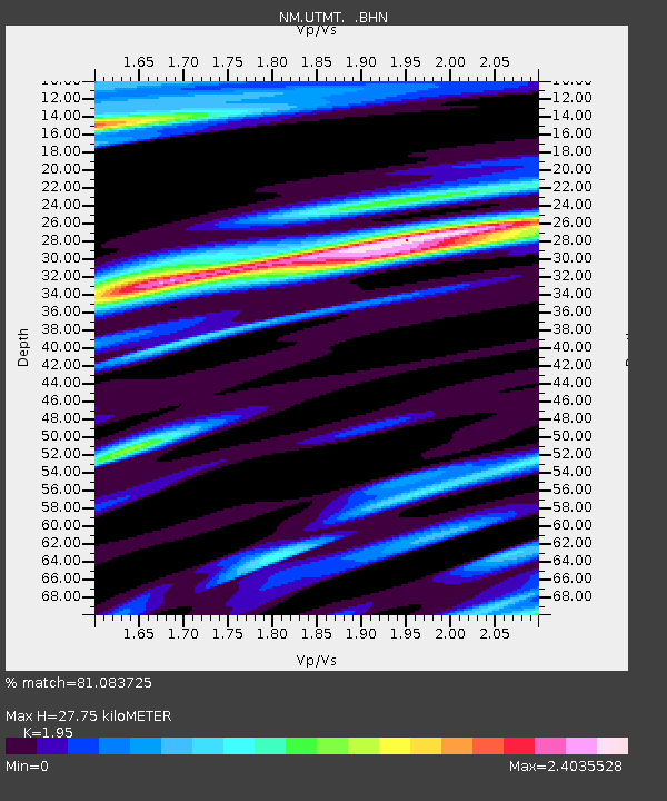
| Estimated Moho Depth: |
27.75 km |
| Estimated Crust Vp/Vs: |
1.95 |
| Assumed Crust Vp: |
6.444 km/s |
| Estimated Crust Vs: |
3.305 km/s |
| Estimated Crust Poisson's Ratio: |
0.32 |
|
| Radial Match: |
81.083725 % |
| Radial Bump: |
400 |
| Transverse Match: |
76.63764 % |
| Transverse Bump: |
400 |
| SOD ConfigId: |
3744 |
| Insert Time: |
2010-03-09 11:42:38.185 +0000 |
| GWidth: |
2.5 |
| Max Bumps: |
400 |
| Tol: |
0.001 |
|
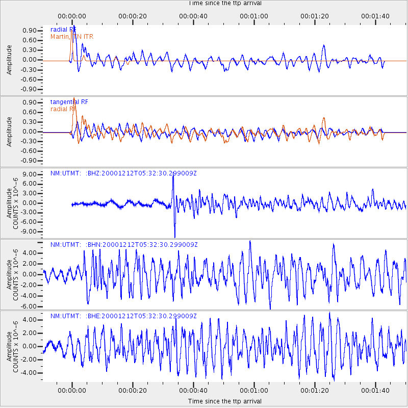
Signal To Noise
| Channel | StoN | STA | LTA |
| NM:UTMT: :BHN:20001212T05:32:30.299009Z | 1.7459654 | 1.3366334E-6 | 7.655555E-7 |
| NM:UTMT: :BHE:20001212T05:32:30.299009Z | 2.46119 | 1.543847E-6 | 6.272767E-7 |
| NM:UTMT: :BHZ:20001212T05:32:30.299009Z | 6.899811 | 3.4496709E-6 | 4.99966E-7 |
| Arrivals |
| Ps | 4.4 SECOND |
| PpPs | 12 SECOND |
| PsPs/PpSs | 16 SECOND |


