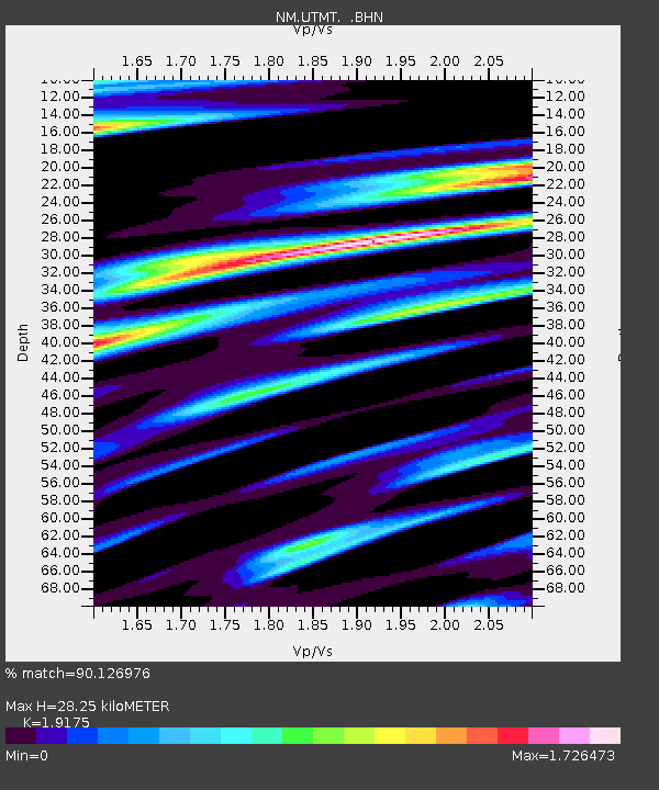
UTMT Martin, TN - Earthquake Result Viewer
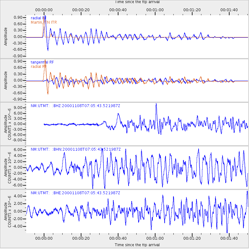
Earthquake location: Panama-Colombia Border Region
Earthquake latitude/longitude: 7.0/-77.8
Earthquake time(UTC): 2000/11/08 (313) 06:59:58 GMT
Earthquake Depth: 17 km
Earthquake Magnitude: 6.0 MB, 6.4 MS, 6.5 MW, 6.2 ML
Earthquake Catalog/Contributor: WHDF/NEIC
Network: NM Cooperative New Madrid Seismic Network
Station: UTMT Martin, TN
Lat/Lon: 36.34 N/88.86 W
Elevation: 120 m
Distance: 30.9 deg
Az: 342.465 deg
Baz: 158.261 deg
Ray Param: 0.07921238
Estimated Moho Depth: 28.25 km
Estimated Crust Vp/Vs: 1.92
Assumed Crust Vp: 6.444 km/s
Estimated Crust Vs: 3.361 km/s
Estimated Crust Poisson's Ratio: 0.31
Radial Match: 90.126976 %
Radial Bump: 400
Transverse Match: 65.18071 %
Transverse Bump: 400
SOD ConfigId: 3744
Insert Time: 2010-03-09 11:42:39.644 +0000
GWidth: 2.5
Max Bumps: 400
Tol: 0.001

Signal To Noise

ChannelStoNSTALTA
NM:UTMT: :BHN:20001108T07:05:43.521987Z1.8548081.0093827E-65.441979E-7
NM:UTMT: :BHE:20001108T07:05:43.521987Z0.615241354.2281286E-76.872309E-7
NM:UTMT: :BHZ:20001108T07:05:43.521987Z4.2466359.883382E-72.3273444E-7
Arrivals
Ps4.3 SECOND
PpPs12 SECOND
PsPs/PpSs16 SECOND