You are here: Home > Network List > AV - Alaska Volcano Observatory Stations List
> Station SPCR Ckakachatna River, Mount Spurr, Alaska > Earthquake Result Viewer
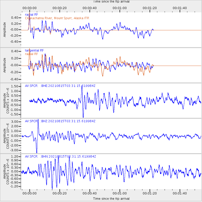
SPCR Ckakachatna River, Mount Spurr, Alaska - Earthquake Result Viewer
*The percent match for this event was below the threshold and hence no stack was calculated.
| Earthquake location: |
Haiti Region |
| Earthquake latitude/longitude: |
18.4/-74.1 |
| Earthquake time(UTC): |
2021/08/15 (227) 03:20:45 GMT |
| Earthquake Depth: |
12 km |
| Earthquake Magnitude: |
5.8 mww |
| Earthquake Catalog/Contributor: |
NEIC PDE/us |
|
| Network: |
AV Alaska Volcano Observatory |
| Station: |
SPCR Ckakachatna River, Mount Spurr, Alaska |
| Lat/Lon: |
61.20 N/152.21 W |
| Elevation: |
984 m |
|
| Distance: |
68.4 deg |
| Az: |
329.35 deg |
| Baz: |
91.202 deg |
| Ray Param: |
$rayparam |
*The percent match for this event was below the threshold and hence was not used in the summary stack. |
|
| Radial Match: |
74.872765 % |
| Radial Bump: |
400 |
| Transverse Match: |
78.57155 % |
| Transverse Bump: |
400 |
| SOD ConfigId: |
25131211 |
| Insert Time: |
2021-08-29 03:27:42.750 +0000 |
| GWidth: |
2.5 |
| Max Bumps: |
400 |
| Tol: |
0.001 |
|
Signal To Noise
| Channel | StoN | STA | LTA |
| AV:SPCR: :BHZ:20210815T03:31:15.619984Z | 10.960872 | 9.855743E-7 | 8.991751E-8 |
| AV:SPCR: :BHN:20210815T03:31:15.619984Z | 1.3583444 | 1.4149036E-7 | 1.04163824E-7 |
| AV:SPCR: :BHE:20210815T03:31:15.619984Z | 3.2073765 | 4.82865E-7 | 1.5054827E-7 |
| Arrivals |
| Ps | |
| PpPs | |
| PsPs/PpSs | |


