You are here: Home > Network List > NM - Cooperative New Madrid Seismic Network Stations List
> Station UTMT Martin, TN > Earthquake Result Viewer
UTMT Martin, TN - Earthquake Result Viewer
| Earthquake location: |
Western Brazil |
| Earthquake latitude/longitude: |
-8.3/-71.7 |
| Earthquake time(UTC): |
2002/10/12 (285) 20:09:11 GMT |
| Earthquake Depth: |
534 km |
| Earthquake Magnitude: |
6.5 MB, 6.9 MW, 6.9 MW |
| Earthquake Catalog/Contributor: |
WHDF/NEIC |
|
| Network: |
NM Cooperative New Madrid Seismic Network |
| Station: |
UTMT Martin, TN |
| Lat/Lon: |
36.34 N/88.86 W |
| Elevation: |
120 m |
|
| Distance: |
47.2 deg |
| Az: |
341.102 deg |
| Baz: |
156.609 deg |
| Ray Param: |
0.06763542 |
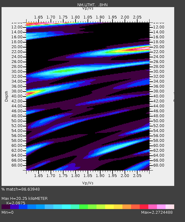
| Estimated Moho Depth: |
20.25 km |
| Estimated Crust Vp/Vs: |
2.10 |
| Assumed Crust Vp: |
6.444 km/s |
| Estimated Crust Vs: |
3.072 km/s |
| Estimated Crust Poisson's Ratio: |
0.35 |
|
| Radial Match: |
86.63948 % |
| Radial Bump: |
400 |
| Transverse Match: |
74.44983 % |
| Transverse Bump: |
400 |
| SOD ConfigId: |
4714 |
| Insert Time: |
2010-03-09 11:42:58.207 +0000 |
| GWidth: |
2.5 |
| Max Bumps: |
400 |
| Tol: |
0.001 |
|
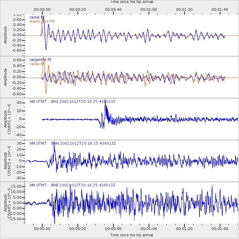
Signal To Noise
| Channel | StoN | STA | LTA |
| NM:UTMT: :BHN:20021012T20:16:25.436013Z | 3.9160733 | 3.7825791E-6 | 9.659112E-7 |
| NM:UTMT: :BHE:20021012T20:16:25.436013Z | 1.789467 | 1.4651537E-6 | 8.1876544E-7 |
| NM:UTMT: :BHZ:20021012T20:16:25.436013Z | 18.964836 | 8.542228E-6 | 4.5042455E-7 |
| Arrivals |
| Ps | 3.6 SECOND |
| PpPs | 9.3 SECOND |
| PsPs/PpSs | 13 SECOND |


