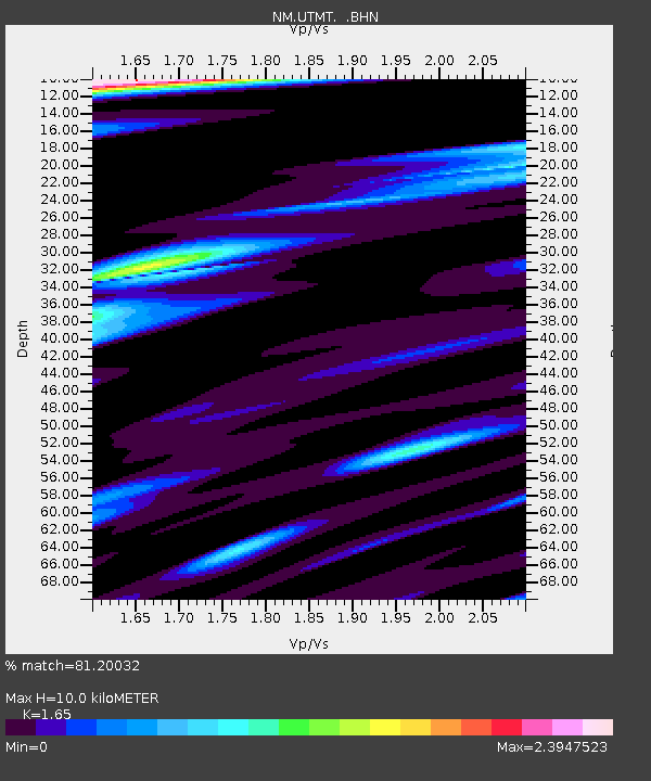
UTMT Martin, TN - Earthquake Result Viewer
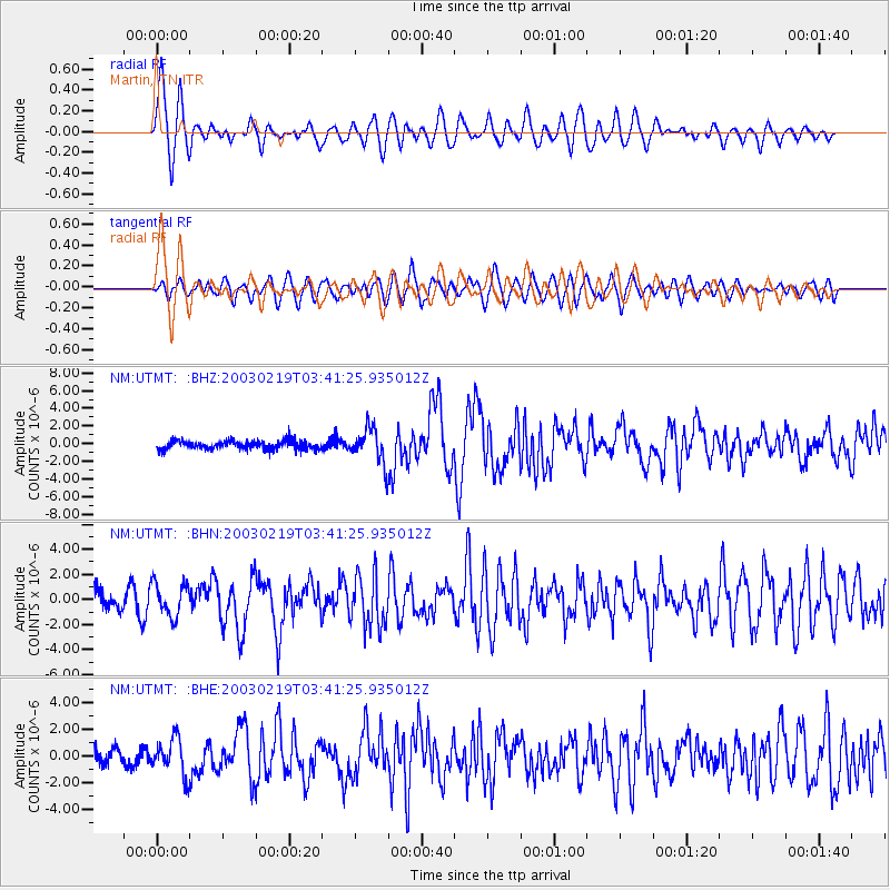
Earthquake location: Unimak Island Region, Alaska
Earthquake latitude/longitude: 53.6/-164.6
Earthquake time(UTC): 2003/02/19 (050) 03:32:36 GMT
Earthquake Depth: 19 km
Earthquake Magnitude: 5.8 MB, 6.6 MS, 6.6 MW, 6.6 MW
Earthquake Catalog/Contributor: WHDF/NEIC
Network: NM Cooperative New Madrid Seismic Network
Station: UTMT Martin, TN
Lat/Lon: 36.34 N/88.86 W
Elevation: 120 m
Distance: 53.7 deg
Az: 76.222 deg
Baz: 314.26 deg
Ray Param: 0.065908134
Estimated Moho Depth: 10.0 km
Estimated Crust Vp/Vs: 1.65
Assumed Crust Vp: 6.444 km/s
Estimated Crust Vs: 3.905 km/s
Estimated Crust Poisson's Ratio: 0.21
Radial Match: 81.20032 %
Radial Bump: 400
Transverse Match: 72.96165 %
Transverse Bump: 400
SOD ConfigId: 4714
Insert Time: 2010-03-09 11:43:00.796 +0000
GWidth: 2.5
Max Bumps: 400
Tol: 0.001

Signal To Noise

ChannelStoNSTALTA
NM:UTMT: :BHN:20030219T03:41:25.935012Z1.6016731.3316151E-68.313901E-7
NM:UTMT: :BHE:20030219T03:41:25.935012Z2.1046311.3793817E-66.554031E-7
NM:UTMT: :BHZ:20030219T03:41:25.935012Z3.9131431.9477006E-64.977331E-7
Arrivals
Ps1.1 SECOND
PpPs3.9 SECOND
PsPs/PpSs4.9 SECOND