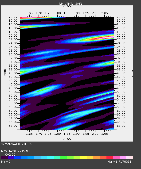
UTMT Martin, TN - Earthquake Result Viewer
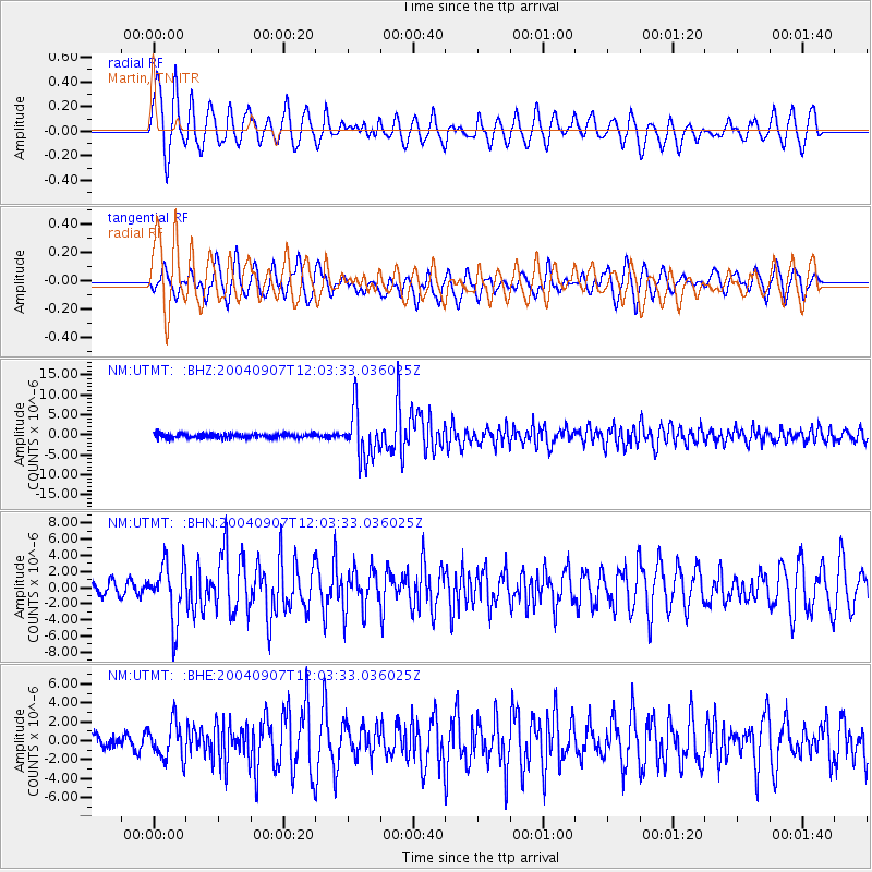
Earthquake location: Santiago Del Estero Prov., Arg.
Earthquake latitude/longitude: -28.6/-65.8
Earthquake time(UTC): 2004/09/07 (251) 11:53:06 GMT
Earthquake Depth: 22 km
Earthquake Magnitude: 6.1 MB, 6.1 MS, 6.4 MW, 6.2 MW
Earthquake Catalog/Contributor: WHDF/NEIC
Network: NM Cooperative New Madrid Seismic Network
Station: UTMT Martin, TN
Lat/Lon: 36.34 N/88.86 W
Elevation: 120 m
Distance: 68.1 deg
Az: 340.104 deg
Baz: 158.239 deg
Ray Param: 0.056492772
Estimated Moho Depth: 20.5 km
Estimated Crust Vp/Vs: 2.09
Assumed Crust Vp: 6.444 km/s
Estimated Crust Vs: 3.083 km/s
Estimated Crust Poisson's Ratio: 0.35
Radial Match: 88.531975 %
Radial Bump: 400
Transverse Match: 85.06315 %
Transverse Bump: 400
SOD ConfigId: 2459
Insert Time: 2010-03-09 11:43:09.123 +0000
GWidth: 2.5
Max Bumps: 400
Tol: 0.001

Signal To Noise

ChannelStoNSTALTA
NM:UTMT: :BHN:20040907T12:03:33.036025Z3.89120863.6293723E-69.3271075E-7
NM:UTMT: :BHE:20040907T12:03:33.036025Z2.6731171.9445702E-67.2745416E-7
NM:UTMT: :BHZ:20040907T12:03:33.036025Z11.6908096.0432208E-65.1692064E-7
Arrivals
Ps3.6 SECOND
PpPs9.5 SECOND
PsPs/PpSs13 SECOND