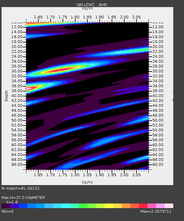
UTMT Martin, TN - Earthquake Result Viewer
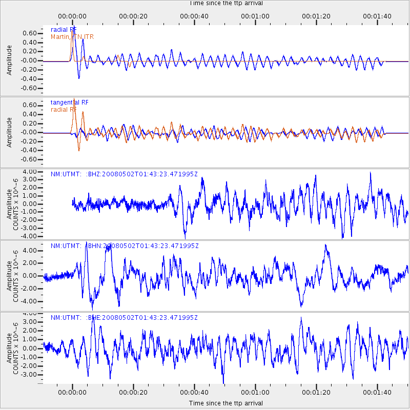
Earthquake location: Andreanof Islands, Aleutian Is.
Earthquake latitude/longitude: 51.9/-177.5
Earthquake time(UTC): 2008/05/02 (123) 01:33:37 GMT
Earthquake Depth: 14 km
Earthquake Magnitude: 6.3 MB, 6.8 MS, 6.6 MW, 6.6 MW
Earthquake Catalog/Contributor: WHDF/NEIC
Network: NM Cooperative New Madrid Seismic Network
Station: UTMT Martin, TN
Lat/Lon: 36.34 N/88.86 W
Elevation: 120 m
Distance: 61.7 deg
Az: 66.492 deg
Baz: 315.228 deg
Ray Param: 0.06071816
Estimated Moho Depth: 37.0 km
Estimated Crust Vp/Vs: 1.60
Assumed Crust Vp: 6.444 km/s
Estimated Crust Vs: 4.027 km/s
Estimated Crust Poisson's Ratio: 0.18
Radial Match: 91.06182 %
Radial Bump: 400
Transverse Match: 72.38305 %
Transverse Bump: 400
SOD ConfigId: 2504
Insert Time: 2010-03-09 11:43:13.660 +0000
GWidth: 2.5
Max Bumps: 400
Tol: 0.001

Signal To Noise

ChannelStoNSTALTA
NM:UTMT: :BHN:20080502T01:43:23.471995Z6.2659192.033323E-63.2450512E-7
NM:UTMT: :BHE:20080502T01:43:23.471995Z2.05871639.971579E-74.8435913E-7
NM:UTMT: :BHZ:20080502T01:43:23.471995Z1.54522186.230736E-74.03226E-7
Arrivals
Ps3.6 SECOND
PpPs14 SECOND
PsPs/PpSs18 SECOND