You are here: Home > Network List > CI - Caltech Regional Seismic Network Stations List
> Station SWS Sam W. Stewart, Westmorland, CA, USA > Earthquake Result Viewer
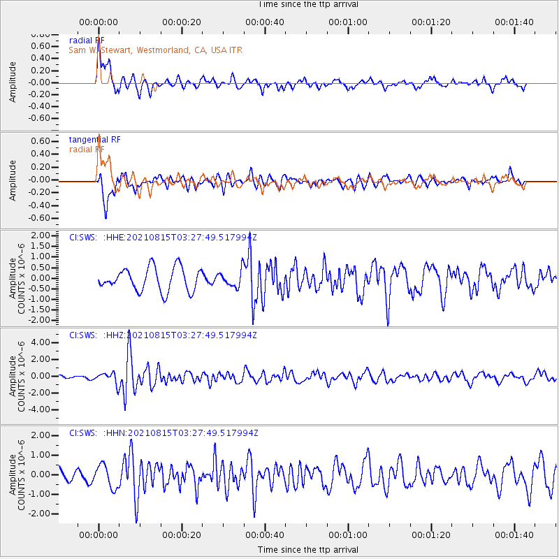
SWS Sam W. Stewart, Westmorland, CA, USA - Earthquake Result Viewer
*The percent match for this event was below the threshold and hence no stack was calculated.
| Earthquake location: |
Haiti Region |
| Earthquake latitude/longitude: |
18.4/-74.1 |
| Earthquake time(UTC): |
2021/08/15 (227) 03:20:45 GMT |
| Earthquake Depth: |
12 km |
| Earthquake Magnitude: |
5.8 mww |
| Earthquake Catalog/Contributor: |
NEIC PDE/us |
|
| Network: |
CI Caltech Regional Seismic Network |
| Station: |
SWS Sam W. Stewart, Westmorland, CA, USA |
| Lat/Lon: |
32.94 N/115.80 W |
| Elevation: |
140 m |
|
| Distance: |
40.0 deg |
| Az: |
299.562 deg |
| Baz: |
100.785 deg |
| Ray Param: |
$rayparam |
*The percent match for this event was below the threshold and hence was not used in the summary stack. |
|
| Radial Match: |
68.00838 % |
| Radial Bump: |
400 |
| Transverse Match: |
81.044266 % |
| Transverse Bump: |
400 |
| SOD ConfigId: |
25131211 |
| Insert Time: |
2021-08-29 03:33:28.424 +0000 |
| GWidth: |
2.5 |
| Max Bumps: |
400 |
| Tol: |
0.001 |
|
Signal To Noise
| Channel | StoN | STA | LTA |
| CI:SWS: :HHZ:20210815T03:27:49.517994Z | 4.3558574 | 7.091518E-7 | 1.6280417E-7 |
| CI:SWS: :HHN:20210815T03:27:49.517994Z | 2.2852988 | 5.9992703E-7 | 2.6251578E-7 |
| CI:SWS: :HHE:20210815T03:27:49.517994Z | 0.72981125 | 3.9916492E-7 | 5.4694266E-7 |
| Arrivals |
| Ps | |
| PpPs | |
| PsPs/PpSs | |


