You are here: Home > Network List > GS - US Geological Survey Networks Stations List
> Station ASA6 ASA6 > Earthquake Result Viewer
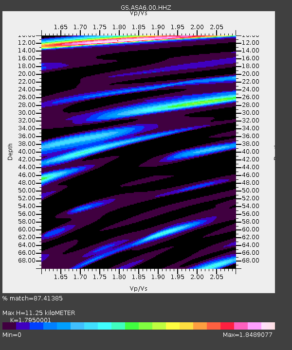
ASA6 ASA6 - Earthquake Result Viewer
| Earthquake location: |
Haiti Region |
| Earthquake latitude/longitude: |
18.4/-74.1 |
| Earthquake time(UTC): |
2021/08/15 (227) 03:20:45 GMT |
| Earthquake Depth: |
12 km |
| Earthquake Magnitude: |
5.8 mww |
| Earthquake Catalog/Contributor: |
NEIC PDE/us |
|
| Network: |
GS US Geological Survey Networks |
| Station: |
ASA6 ASA6 |
| Lat/Lon: |
34.94 N/106.46 W |
| Elevation: |
1840 m |
|
| Distance: |
33.1 deg |
| Az: |
306.394 deg |
| Baz: |
111.485 deg |
| Ray Param: |
0.07835586 |
| Estimated Moho Depth: |
11.25 km |
| Estimated Crust Vp/Vs: |
1.80 |
| Assumed Crust Vp: |
6.502 km/s |
| Estimated Crust Vs: |
3.622 km/s |
| Estimated Crust Poisson's Ratio: |
0.27 |
|
| Radial Match: |
87.41385 % |
| Radial Bump: |
374 |
| Transverse Match: |
79.65923 % |
| Transverse Bump: |
400 |
| SOD ConfigId: |
25131211 |
| Insert Time: |
2021-08-29 03:37:26.887 +0000 |
| GWidth: |
2.5 |
| Max Bumps: |
400 |
| Tol: |
0.001 |
|

Signal To Noise
| Channel | StoN | STA | LTA |
| GS:ASA6:00:HHZ:20210815T03:26:50.668995Z | 2.9865246 | 4.492164E-7 | 1.5041444E-7 |
| GS:ASA6:00:HH1:20210815T03:26:50.668995Z | 2.859054 | 1.5402387E-7 | 5.3872316E-8 |
| GS:ASA6:00:HH2:20210815T03:26:50.668995Z | 4.8441315 | 2.688874E-7 | 5.5507865E-8 |
| Arrivals |
| Ps | 1.5 SECOND |
| PpPs | 4.5 SECOND |
| PsPs/PpSs | 6.0 SECOND |


