You are here: Home > Network List > N4 - Central and EAstern US Network Stations List
> Station MDND Maddock, ND, USA > Earthquake Result Viewer
MDND Maddock, ND, USA - Earthquake Result Viewer
| Earthquake location: |
Haiti Region |
| Earthquake latitude/longitude: |
18.4/-74.1 |
| Earthquake time(UTC): |
2021/08/15 (227) 03:20:45 GMT |
| Earthquake Depth: |
12 km |
| Earthquake Magnitude: |
5.8 mww |
| Earthquake Catalog/Contributor: |
NEIC PDE/us |
|
| Network: |
N4 Central and EAstern US Network |
| Station: |
MDND Maddock, ND, USA |
| Lat/Lon: |
47.85 N/99.60 W |
| Elevation: |
479 m |
|
| Distance: |
36.0 deg |
| Az: |
330.445 deg |
| Baz: |
135.938 deg |
| Ray Param: |
0.07692993 |
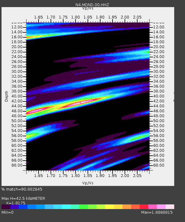
| Estimated Moho Depth: |
42.5 km |
| Estimated Crust Vp/Vs: |
1.82 |
| Assumed Crust Vp: |
6.53 km/s |
| Estimated Crust Vs: |
3.593 km/s |
| Estimated Crust Poisson's Ratio: |
0.28 |
|
| Radial Match: |
90.882645 % |
| Radial Bump: |
397 |
| Transverse Match: |
76.299774 % |
| Transverse Bump: |
400 |
| SOD ConfigId: |
25131211 |
| Insert Time: |
2021-08-29 03:39:41.345 +0000 |
| GWidth: |
2.5 |
| Max Bumps: |
400 |
| Tol: |
0.001 |
|

Signal To Noise
| Channel | StoN | STA | LTA |
| N4:MDND:00:HHZ:20210815T03:27:15.739002Z | 16.361956 | 1.9120132E-6 | 1.1685725E-7 |
| N4:MDND:00:HH1:20210815T03:27:15.739002Z | 4.382684 | 9.827725E-7 | 2.2423987E-7 |
| N4:MDND:00:HH2:20210815T03:27:15.739002Z | 1.930472 | 6.6442743E-7 | 3.4417874E-7 |
| Arrivals |
| Ps | 5.7 SECOND |
| PpPs | 17 SECOND |
| PsPs/PpSs | 23 SECOND |


