You are here: Home > Network List > US - United States National Seismic Network Stations List
> Station DGMT Dagmar, Montana, USA > Earthquake Result Viewer
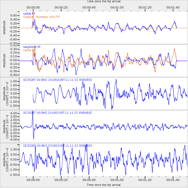
DGMT Dagmar, Montana, USA - Earthquake Result Viewer
*The percent match for this event was below the threshold and hence no stack was calculated.
| Earthquake location: |
Andreanof Islands, Aleutian Is. |
| Earthquake latitude/longitude: |
52.6/-179.5 |
| Earthquake time(UTC): |
2018/02/08 (039) 11:04:01 GMT |
| Earthquake Depth: |
211 km |
| Earthquake Magnitude: |
5.6 Mww |
| Earthquake Catalog/Contributor: |
NEIC PDE/us |
|
| Network: |
US United States National Seismic Network |
| Station: |
DGMT Dagmar, Montana, USA |
| Lat/Lon: |
48.47 N/104.20 W |
| Elevation: |
0.0 m |
|
| Distance: |
46.0 deg |
| Az: |
63.46 deg |
| Baz: |
304.861 deg |
| Ray Param: |
$rayparam |
*The percent match for this event was below the threshold and hence was not used in the summary stack. |
|
| Radial Match: |
52.30146 % |
| Radial Bump: |
400 |
| Transverse Match: |
52.856995 % |
| Transverse Bump: |
400 |
| SOD ConfigId: |
2546091 |
| Insert Time: |
2018-02-22 11:11:37.420 +0000 |
| GWidth: |
2.5 |
| Max Bumps: |
400 |
| Tol: |
0.001 |
|
Signal To Noise
| Channel | StoN | STA | LTA |
| US:DGMT:00:BHZ:20180208T11:11:32.898989Z | 8.099197 | 1.6449434E-6 | 2.0309956E-7 |
| US:DGMT:00:BH1:20180208T11:11:32.898989Z | 1.2579231 | 5.983838E-7 | 4.7569185E-7 |
| US:DGMT:00:BH2:20180208T11:11:32.898989Z | 1.2624897 | 7.13617E-7 | 5.6524584E-7 |
| Arrivals |
| Ps | |
| PpPs | |
| PsPs/PpSs | |


