You are here: Home > Network List > UW - Pacific Northwest Regional Seismic Network Stations List
> Station WYNO Wynoochee Dam Area, Olympic National Forest, WA, USA > Earthquake Result Viewer
WYNO Wynoochee Dam Area, Olympic National Forest, WA, USA - Earthquake Result Viewer
| Earthquake location: |
Haiti Region |
| Earthquake latitude/longitude: |
18.4/-74.1 |
| Earthquake time(UTC): |
2021/08/15 (227) 03:20:45 GMT |
| Earthquake Depth: |
12 km |
| Earthquake Magnitude: |
5.8 mww |
| Earthquake Catalog/Contributor: |
NEIC PDE/us |
|
| Network: |
UW Pacific Northwest Regional Seismic Network |
| Station: |
WYNO Wynoochee Dam Area, Olympic National Forest, WA, USA |
| Lat/Lon: |
47.43 N/123.61 W |
| Elevation: |
935 m |
|
| Distance: |
49.6 deg |
| Az: |
317.281 deg |
| Baz: |
108.383 deg |
| Ray Param: |
0.06863347 |
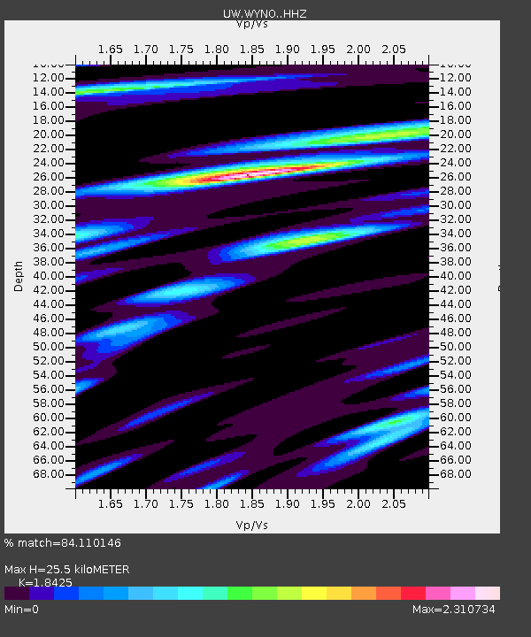
| Estimated Moho Depth: |
25.5 km |
| Estimated Crust Vp/Vs: |
1.84 |
| Assumed Crust Vp: |
6.566 km/s |
| Estimated Crust Vs: |
3.564 km/s |
| Estimated Crust Poisson's Ratio: |
0.29 |
|
| Radial Match: |
84.110146 % |
| Radial Bump: |
400 |
| Transverse Match: |
69.76575 % |
| Transverse Bump: |
400 |
| SOD ConfigId: |
25131211 |
| Insert Time: |
2021-08-29 03:47:31.316 +0000 |
| GWidth: |
2.5 |
| Max Bumps: |
400 |
| Tol: |
0.001 |
|

Signal To Noise
| Channel | StoN | STA | LTA |
| UW:WYNO: :HHZ:20210815T03:29:05.409992Z | 7.366828 | 7.8674947E-7 | 1.06796236E-7 |
| UW:WYNO: :HHN:20210815T03:29:05.409992Z | 3.2070441 | 4.0532635E-7 | 1.2638627E-7 |
| UW:WYNO: :HHE:20210815T03:29:05.409992Z | 3.9059608 | 4.6850025E-7 | 1.1994494E-7 |
| Arrivals |
| Ps | 3.5 SECOND |
| PpPs | 10 SECOND |
| PsPs/PpSs | 14 SECOND |


