You are here: Home > Network List > C1 - Red Sismologica Nacional Stations List
> Station MT09 Talagante > Earthquake Result Viewer
MT09 Talagante - Earthquake Result Viewer
| Earthquake location: |
South Sandwich Islands Region |
| Earthquake latitude/longitude: |
-60.4/-28.1 |
| Earthquake time(UTC): |
2021/08/15 (227) 16:34:51 GMT |
| Earthquake Depth: |
10 km |
| Earthquake Magnitude: |
5.5 Mww |
| Earthquake Catalog/Contributor: |
NEIC PDE/us |
|
| Network: |
C1 Red Sismologica Nacional |
| Station: |
MT09 Talagante |
| Lat/Lon: |
33.78 S/70.99 W |
| Elevation: |
1371 m |
|
| Distance: |
38.5 deg |
| Az: |
294.182 deg |
| Baz: |
147.069 deg |
| Ray Param: |
0.075579725 |
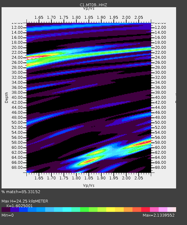
| Estimated Moho Depth: |
24.25 km |
| Estimated Crust Vp/Vs: |
1.60 |
| Assumed Crust Vp: |
6.481 km/s |
| Estimated Crust Vs: |
4.044 km/s |
| Estimated Crust Poisson's Ratio: |
0.18 |
|
| Radial Match: |
85.33152 % |
| Radial Bump: |
400 |
| Transverse Match: |
69.880226 % |
| Transverse Bump: |
400 |
| SOD ConfigId: |
25131211 |
| Insert Time: |
2021-08-29 16:36:21.408 +0000 |
| GWidth: |
2.5 |
| Max Bumps: |
400 |
| Tol: |
0.001 |
|

Signal To Noise
| Channel | StoN | STA | LTA |
| C1:MT09: :HHZ:20210815T16:41:42.359988Z | 2.480146 | 3.5001494E-7 | 1.4112676E-7 |
| C1:MT09: :HHN:20210815T16:41:42.359988Z | 1.9857413 | 1.9629118E-7 | 9.8850336E-8 |
| C1:MT09: :HHE:20210815T16:41:42.359988Z | 1.2011423 | 2.398028E-7 | 1.9964561E-7 |
| Arrivals |
| Ps | 2.4 SECOND |
| PpPs | 9.0 SECOND |
| PsPs/PpSs | 11 SECOND |


