You are here: Home > Network List > G - GEOSCOPE Stations List
> Station MPG Montagne des Peres, French Guyana > Earthquake Result Viewer
MPG Montagne des Peres, French Guyana - Earthquake Result Viewer
| Earthquake location: |
South Sandwich Islands Region |
| Earthquake latitude/longitude: |
-58.4/-24.3 |
| Earthquake time(UTC): |
2021/08/12 (224) 23:50:11 GMT |
| Earthquake Depth: |
10 km |
| Earthquake Magnitude: |
5.5 mb |
| Earthquake Catalog/Contributor: |
NEIC PDE/us |
|
| Network: |
G GEOSCOPE |
| Station: |
MPG Montagne des Peres, French Guyana |
| Lat/Lon: |
5.11 N/52.64 W |
| Elevation: |
147 m |
|
| Distance: |
67.2 deg |
| Az: |
329.174 deg |
| Baz: |
164.272 deg |
| Ray Param: |
0.057092454 |
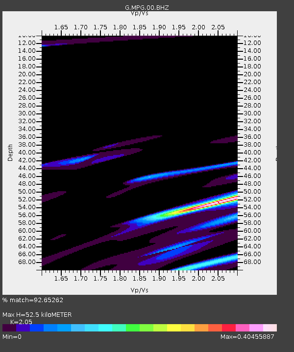
| Estimated Moho Depth: |
52.5 km |
| Estimated Crust Vp/Vs: |
2.05 |
| Assumed Crust Vp: |
6.472 km/s |
| Estimated Crust Vs: |
3.157 km/s |
| Estimated Crust Poisson's Ratio: |
0.34 |
|
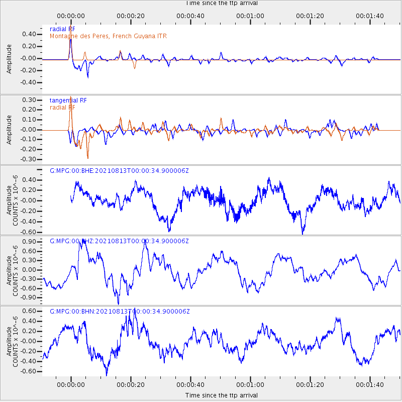
| Radial Match: |
92.65262 % |
| Radial Bump: |
308 |
| Transverse Match: |
67.76596 % |
| Transverse Bump: |
400 |
| SOD ConfigId: |
25131211 |
| Insert Time: |
2021-08-30 04:34:45.892 +0000 |
| GWidth: |
2.5 |
| Max Bumps: |
400 |
| Tol: |
0.001 |
|
Signal To Noise
| Channel | StoN | STA | LTA |
| G:MPG:00:BHZ:20210813T00:00:34.900006Z | 1.1944065 | 6.5276555E-7 | 5.465187E-7 |
| G:MPG:00:BHN:20210813T00:00:34.900006Z | 0.7808411 | 2.8182842E-7 | 3.6092928E-7 |
| G:MPG:00:BHE:20210813T00:00:34.900006Z | 3.5507214 | 4.656389E-7 | 1.3113923E-7 |
| Arrivals |
| Ps | 8.8 SECOND |
| PpPs | 24 SECOND |
| PsPs/PpSs | 33 SECOND |


